4.12 Test Excavation 167 (T-167) - Honolulu Rail Transit Project
4.12 Test Excavation 167 (T-167) - Honolulu Rail Transit Project
4.12 Test Excavation 167 (T-167) - Honolulu Rail Transit Project
Create successful ePaper yourself
Turn your PDF publications into a flip-book with our unique Google optimized e-Paper software.
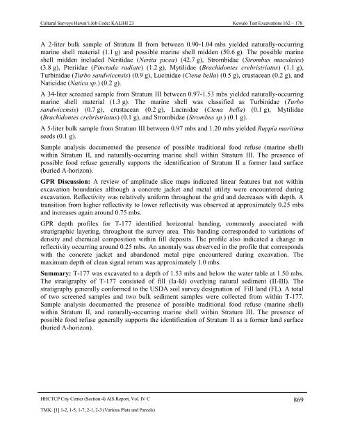
Cultural Surveys Hawai‘i Job Code: KALIHI 23 Kewalo <strong>Test</strong> <strong>Excavation</strong>s 162 – 178A 2-liter bulk sample of Stratum II from between 0.90-1.04 mbs yielded naturally-occurringmarine shell material (1.1 g) and possible marine shell midden (50.6 g). The possible marineshell midden included Neritidae (Nerita picea) (42.7 g), Strombidae (Strombus maculates)(3.8 g), Pteriidae (Pinctada radiate) (1.2 g), Mytilidae (Brachidontes crebristriatus) (1.1 g),Turbinidae (Turbo sandwicensis) (0.9 g), Lucinidae (Ctena bella) (0.5 g), crustacean (0.2 g), andNaticidae (Natica sp.) (0.2 g).A 34-liter screened sample from Stratum III between 0.97-1.53 mbs yielded naturally-occurringmarine shell material (1.3 g). The marine shell was classified as Turbinidae (Turbosandwicensis) (0.7 g), crustacean (0.2 g), Lucinidae (Ctena bella) (0.1 g), Mytilidae(Brachidontes crebristriatus) (0.1 g), and Strombidae (Strombus sp.) (0.1 g).A 5-liter bulk sample from Stratum III between 0.97 mbs and 1.20 mbs yielded Ruppia maritimaseeds (0.1 g).Sample analysis documented the presence of possible traditional food refuse (marine shell)within Stratum II, and naturally-occurring marine shell within Stratum III. The presence ofpossible food refuse generally supports the identification of Stratum II a former land surface(buried A-horizon).GPR Discussion: A review of amplitude slice maps indicated linear features but not withinexcavation boundaries although a concrete jacket and metal utility were encountered duringexcavation. Reflectivity was relatively uniform throughout the grid and decreases with depth. Atransition from higher reflectivity to lower reflectivity was observed at approximately 0.25 mbsand increases again around 0.75 mbs.GPR depth profiles for T-177 identified horizontal banding, commonly associated withstratigraphic layering, throughout the survey area. This banding corresponded to variations ofdensity and chemical composition within fill deposits. The profile also indicated a change inreflectivity occurring around 0.25 mbs. An anomaly was observed in the profile that correspondswith the concrete jacket and abandoned metal pipe encountered during excavation. Themaximum depth of clean signal return was approximately 1.0 mbs.Summary: T-177 was excavated to a depth of 1.53 mbs and below the water table at 1.50 mbs.The stratigraphy of T-177 consisted of fill (Ia-Id) overlying natural sediment (II-III). Thestratigraphy generally conformed to the USDA soil survey designation of Fill land (FL). A totalof two screened samples and two bulk sediment samples were collected from within T-177.Sample analysis documented the presence of possible traditional food refuse (marine shell)within Stratum II, and naturally-occurring marine shell within Stratum III. The presence ofpossible food refuse generally supports the identification of Stratum II as a former land surface(buried A-horizon).HHCTCP City Center (Section 4) AIS Report, Vol. IV C 869TMK: [1] 1-2, 1-5, 1-7, 2-1, 2-3 (Various Plats and Parcels)


