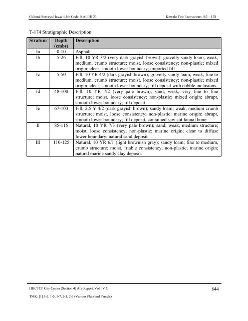
Cultural Surveys Hawai‘i Job Code: KALIHI 23 Kewalo <strong>Test</strong> <strong>Excavation</strong>s 162 – 178T-174 Stratigraphic DescriptionStratum Depth Description(cmbs)Ia 0-10 AsphaltIb 5-26 Fill; 10 YR 3/2 (very dark grayish brown); gravelly sandy loam; weak,medium, crumb structure; moist, loose consistency; non-plastic; mixedorigin; clear, smooth lower boundary; imported fillIc 5-50 Fill; 10 YR 4/2 (dark grayish brown); gravelly sandy loam; weak, fine tomedium, crumb structure; moist, loose consistency; non-plastic; mixedorigin; clear, smooth lower boundary; fill deposit with cobble inclusionsId 48-100 Fill; 10 YR 7/2 (very pale brown); sand; weak, very fine to finestructure; moist, loose consistency; non-plastic; mixed origin; abrupt,smooth lower boundary; fill depositIe 67-103 Fill; 2.5 Y 4/2 (dark grayish brown); sandy loam; weak, medium crumbstructure; moist, loose consistency; non-plastic; marine origin; abrupt,smooth lower boundary; fill deposit, contained saw cut faunal boneII 85-115 Natural, 10 YR 7/3 (very pale brown); sand; weak, medium structure;moist, loose consistency; non-plastic; marine origin; clear to diffuselower boundary; natural sand depositIII 110-125 Natural, 10 YR 6/1 (light brownish gray); sandy loam; fine to medium,crumb structure; moist, friable consistency; non-plastic; marine origin;natural marine sandy clay deposit.HHCTCP City Center (Section 4) AIS Report, Vol. IV C 844TMK: [1] 1-2, 1-5, 1-7, 2-1, 2-3 (Various Plats and Parcels)
Cultural Surveys Hawai‘i Job Code: KALIHI 23 Kewalo <strong>Test</strong> <strong>Excavation</strong>s 162 – 1784.24 <strong>Test</strong> <strong>Excavation</strong> 174A (T-174A)Ahupua‘a:LCA : 387<strong>Honolulu</strong>TMK #: 2-3-002:001Elevation Above Sea Level:UTM:Max Length/Width/Depth:Orientation:Targeted <strong>Project</strong> Component:USDA Soil Survey Designation:1.43 m618982.8106 mE, 2355314.56 mN4.47 m / 0.81 m / 1.57 m359 / 179° TNUtility RelocationFill land (FL)Setting: <strong>Test</strong> <strong>Excavation</strong> 174A (T-174 A) was located within the DKKY Architecture ParkingLot, behind the Office Depot. T-174A was an additional excavation added to increase testingcoverage area for a utility relocation and to further investigate the natural land surfacesdocumented in T-174. T-174A also investigated a utility relocation. T-174A was located onprivate property owned by Victoria Ward Ltd. 8 m southwest of a storm drain, and 13.0 msouthwest of a water line. The excavation surface was level with the surrounding land surface.Summary of Background Research and Land: Land Court Application 670 map 1 indicatesthat T-174A was originally situated on a large parcel of land awarded to the American Board ofCommissioners for Foreign Missions (ABCFM) as part of LCA 387. The LCA testimoniesindicated taro cultivation, fishpond farming, and salt production in the region. The 1884 Bishopmap of <strong>Honolulu</strong> to Kewalo indicates that T-174A was located within marsh land calledKukuluaeo, 180.0 m southeast of LCA 10463:1, awarded to Napela. An unimproved or plannedroadway is also depicted, extending northeast (mauka) to southwest (makai) within 145.0 m ofT-174A. The roadway is also depicted on the 1887 Wall map of <strong>Honolulu</strong>. The 1897 Monsarratmap of <strong>Honolulu</strong> depicts infrastructure development immediately north of, and including T-174A, which is depicted within Queen Street and 45.0 m southeast of the Queen Street andCummins Street intersection. Expanded urbanization in the vicinity of T-174A is depictedthroughout the series of twentieth century topographic maps and Sanborn fire insurance maps.Several archaeological studies have been conducted in the vicinity of T-174A. In 2000, CSHconducted archaeological monitoring for Ward Village Phase II (Ward Theaters), approximately100.0 m south of T-174A. A buried A-horizon and naturally-deposited pond sediments weredocumented in portions of the project area but, no cultural resources were assigned (Winieskiand Hammatt 2001). In 2002, CSH conducted archaeological monitoring for the Kaka’akoImprovement District 7 (ID-7) <strong>Project</strong> along Kamake‘e Street from Queen Street to Ala MoanaBoulevard. Three human burials (SIHP# 50-80-14-6376, -6377, and -6378) were inadvertentlydiscovered during the project, one of which was encountered within a beach sand deposit (Souzaet al. 2002). In 2004, Pacific Consulting Services, Inc conducted a subsurface archaeologicalinventory survey at Kapi‘olani Boulevard and Kamake‘e Street and noted remnants of theKewalo wetlands surface (SIHP# 50-80-14-6636) (Clark and Gosser 2005). In 2005, CSHHHCTCP City Center (Section 4) AIS Report, Vol. IV C 845TMK: [1] 1-2, 1-5, 1-7, 2-1, 2-3 (Various Plats and Parcels)