Administrative Adjustment - Currituck County Government
Administrative Adjustment - Currituck County Government
Administrative Adjustment - Currituck County Government

You also want an ePaper? Increase the reach of your titles
YUMPU automatically turns print PDFs into web optimized ePapers that Google loves.
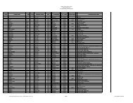
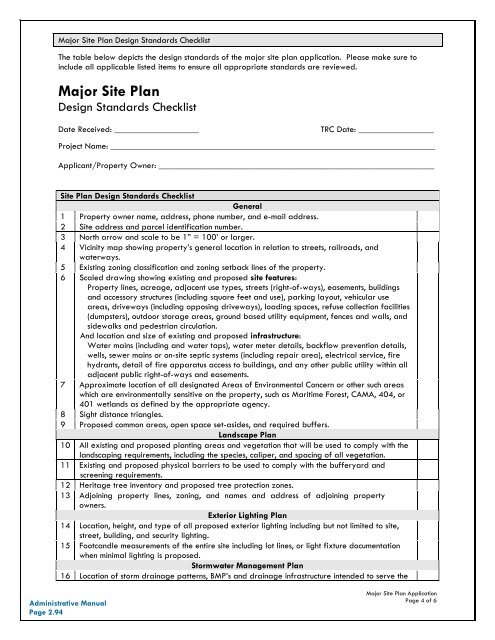
Major Site Plan Design Standards ChecklistThe table below depicts the design standards of the major site plan application. Please make sure toinclude all applicable listed items to ensure all appropriate standards are reviewed.Major Site PlanDesign Standards ChecklistDate Received: ___________________TRC Date: _________________Project Name: _________________________________________________________________________Applicant/Property Owner: ______________________________________________________________Site Plan Design Standards ChecklistGeneral1 Property owner name, address, phone number, and e-mail address.2 Site address and parcel identification number.3 North arrow and scale to be 1” = 100’ or larger.4 Vicinity map showing property’s general location in relation to streets, railroads, andwaterways.5 Existing zoning classification and zoning setback lines of the property.6 Scaled drawing showing existing and proposed site features:Property lines, acreage, adjacent use types, streets (right-of-ways), easements, buildingsand accessory structures (including square feet and use), parking layout, vehicular useareas, driveways (including opposing driveways), loading spaces, refuse collection facilities(dumpsters), outdoor storage areas, ground based utility equipment, fences and walls, andsidewalks and pedestrian circulation.And location and size of existing and proposed infrastructure:Water mains (including and water taps), water meter details, backflow prevention details,wells, sewer mains or on-site septic systems (including repair area), electrical service, firehydrants, detail of fire apparatus access to buildings, and any other public utility within alladjacent public right-of-ways and easements.7 Approximate location of all designated Areas of Environmental Concern or other such areaswhich are environmentally sensitive on the property, such as Maritime Forest, CAMA, 404, or401 wetlands as defined by the appropriate agency.8 Sight distance triangles.9 Proposed common areas, open space set-asides, and required buffers.Landscape Plan10 All existing and proposed planting areas and vegetation that will be used to comply with thelandscaping requirements, including the species, caliper, and spacing of all vegetation.11 Existing and proposed physical barriers to be used to comply with the bufferyard andscreening requirements.12 Heritage tree inventory and proposed tree protection zones.13 Adjoining property lines, zoning, and names and address of adjoining propertyowners.Exterior Lighting Plan14 Location, height, and type of all proposed exterior lighting including but not limited to site,street, building, and security lighting.15 Footcandle measurements of the entire site including lot lines, or light fixture documentationwhen minimal lighting is proposed.Stormwater Management Plan16 Location of storm drainage patterns, BMP’s and drainage infrastructure intended to serve the<strong>Administrative</strong> ManualPage 2.94Major Site Plan ApplicationPage 4 of 6