Administrative Adjustment - Currituck County Government
Administrative Adjustment - Currituck County Government
Administrative Adjustment - Currituck County Government

Create successful ePaper yourself
Turn your PDF publications into a flip-book with our unique Google optimized e-Paper software.
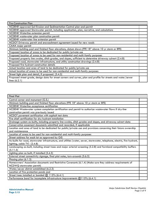
Pre-Construction PlanNCDENR approved Soil Erosion and Sedimentation Control plan and permitNCDENR approved Stormwater permit, including application, plan, narrative, and calculationsNCDENR Waterline extension permitNCDENR wastewater plan construction permitNCDENR wastewater line extension permitNCDOT Driveway permit and encroachment agreement issued for new roadsCAMA major permitMinimum building pad and finished floor elevations, datum shown (FFE 18” above 10 yr storm or BFE)Proposed location of areas to be dedicated for public/private useProposed location of areas to be used for non-residential and multi-family purposesProposed property line swales, ditch grades, and slopes, sufficient to determine driveway culvert (2.4.8)Proposed road, stormwater infrastructure, and utility construction drawings (2.4.8)Proposed fire hydrant construction detailsActual location and area of land to be dedicated for public/private useActual location of areas to be used for non-residential and multi-family purposesStreet light plan and detail, if proposed. (5.4.5)Proposed street grade, design data for street corners and curves, plan and profile for streets and water/sewerlines (6.2.1)Final PlatControl corner and monument (G.S.)Minimum building pad and finished floor elevations (FFE 18” above 10 yr storm or BFE)NCDENR Waterline acceptance certificationNCDENR Wastewater system completion certification and permit to authorize wastewater flows if dry-lineconstruction permit was previously issuedNCDOT pavement certification with asphalt test dataFire chief certification for dry hydrant installationDrainage system as-builts, including property line swales, ditch grades and slopes, and driveway culvert dataConservation easement documents submitted and recorded, if applicableLocation and area of land to be dedicated for public/private use and provisions concerning their future ownershipand maintenanceLocation of areas to be used for non-residential and multi-family purposesStreet address for each lot as approved by GISAs-builts for road, stormwater infrastructure, and utilities (water, sewer, stormwater, telephone, electric, fire hydrant,lighting, cable TV) (2.4.8)Landscaping as-built, including street trees and major arterial screening (5.2.8) and farmland compatibility buffers(5.11.5)Lighting plan as built, if installed (5.4.5)External street connectivity signage, final plat notes, turn-arounds (5.6.5)Phasing plan (6.1.3)Homeowners’ Association documents and Restrictive Covenants (6.1.4) (Make sure they address requirements ofNCDWQ stormwater permit)Water/sewer district established (6.2.3)Location of fire protection ponds andStreet trees installed or bonded @ 115% (6.4.1)Performance bond for incomplete infrastructure improvements @115% (6.4.1)<strong>Administrative</strong> ManualPage 3.15Major Subdivision Staff Review ChecklistPage 3 of 9