Guidelines for Best Practice and Quality Checking of Ortho Imagery
Guidelines for Best Practice and Quality Checking of Ortho Imagery
Guidelines for Best Practice and Quality Checking of Ortho Imagery

Create successful ePaper yourself
Turn your PDF publications into a flip-book with our unique Google optimized e-Paper software.
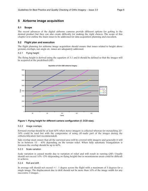
<strong>Guidelines</strong> <strong>for</strong> <strong>Best</strong> <strong>Practice</strong> <strong>and</strong> <strong>Quality</strong> <strong>Checking</strong> <strong>of</strong> <strong>Ortho</strong> <strong>Imagery</strong> – Issue 3.0 Page 65 Airborne image acquisition5.1 ScopeThe recent advances <strong>of</strong> the digital airborne cameras provide different options <strong>for</strong> getting to thedesired product but they can also create difficulty <strong>for</strong> making the right choices. The scope <strong>of</strong> thischapter is to outline the main issues to be addressed <strong>for</strong> data acquisition planning <strong>and</strong> execution.5.2 Flight plan <strong>and</strong> executionThe flight planning <strong>for</strong> airborne image acquisition should ensure that issues related to height aboveground, overlaps, sun angle etc. issues are adequately addressed.5.2.1 Flying heightThe flying height is derived using the equation <strong>of</strong> 3.1 <strong>and</strong> it should be defined so that the images willbe acquired at the predefined GSD.Aquisition <strong>of</strong> 0.5m GSD airborne imagery800070006000h (m)5000400030006.5 µm9 µm12 µm15 µm20 µm20001000060 80 100 120 150f (mm)Figure 1. Flying height <strong>for</strong> different camera configuration (f, CCD size).5.2.2 Image overlapsForward overlap should be at least 60% when stereo imagery is collected whereas <strong>for</strong> mosaicking 20-30% could be used but with the compromise <strong>of</strong> using <strong>of</strong>f-nadir part <strong>of</strong> the images during theorthorectification (not recommended).Side overlap must ensure that all the surveyed area will be covered with imagery <strong>and</strong> generally it willbe in between 15 – 45% depending on the terrain relief. When fully automatic triangulation is<strong>for</strong>eseen the overlap should be up to 60%.5.2.3 Scale variationScale variation is caused mostly due to variation <strong>of</strong> relief <strong>and</strong> will result in varying GSD. Usuallyshould not exceed 10%-15% (depending on flying height) but in mountainous areas could be difficultto achieve.5.2.4 Roll <strong>and</strong> driftIn average roll should not exceed +/- 1 degree across the flight with a maximum <strong>of</strong> 3 degrees <strong>for</strong> asingle image. The displacement due to drift should not be more than 10% <strong>of</strong> the image width <strong>for</strong> anysuccessive 3 images.