Guidelines for Best Practice and Quality Checking of Ortho Imagery
Guidelines for Best Practice and Quality Checking of Ortho Imagery
Guidelines for Best Practice and Quality Checking of Ortho Imagery

You also want an ePaper? Increase the reach of your titles
YUMPU automatically turns print PDFs into web optimized ePapers that Google loves.
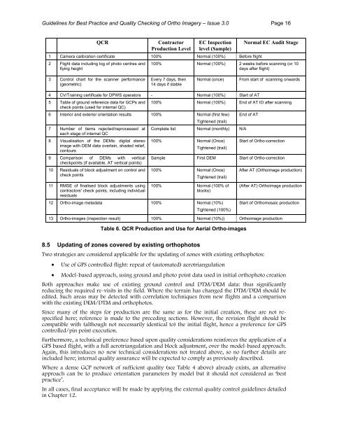
<strong>Guidelines</strong> <strong>for</strong> <strong>Best</strong> <strong>Practice</strong> <strong>and</strong> <strong>Quality</strong> <strong>Checking</strong> <strong>of</strong> <strong>Ortho</strong> <strong>Imagery</strong> – Issue 3.0 Page 16QCRContractorProduction LevelEC Inspectionlevel (Sample)1 Camera calibration certificate 100% Normal (100%) Be<strong>for</strong>e flight2 Flight data including log <strong>of</strong> photo centres <strong>and</strong>flying heightNormal EC Audit Stage100% Normal (100%) 2 weeks be<strong>for</strong>e scanning (or 10days after flight)3 Control chart <strong>for</strong> the scanner per<strong>for</strong>mance(geometric)Every 7 days, then14 days if stableNormal (once)From start <strong>of</strong> scanning onwards4 CV/Training certificate <strong>for</strong> DPWS operators - Normal (100%) Start <strong>of</strong> AT5 Table <strong>of</strong> ground reference data <strong>for</strong> GCPs <strong>and</strong>check points (used <strong>for</strong> internal QC)100% Normal (100%) End <strong>of</strong> AT IO after scanning6 Interior <strong>and</strong> exterior orientation results 100% Normal (first few)Tightened (trail)7 Number <strong>of</strong> items rejected/reprocessed ateach stage <strong>of</strong> internal QC8 Visualisation <strong>of</strong> the DEMs: digital stereoimage with DEM data overlain, shaded relief,contours9 Comparison <strong>of</strong> DEMs with verticalcheckpoints (if available, AT vertical points)10 Residuals <strong>of</strong> block adjustment on control <strong>and</strong>check pointsComplete list Normal (monthly) N/A100% Normal (Once)Tightened (trail)End <strong>of</strong> ATStart <strong>of</strong> <strong>Ortho</strong>-correctionSample First DEM Start <strong>of</strong> <strong>Ortho</strong>-correction100% Normal (Once)Tightened (trail)After AT (<strong>Ortho</strong>image production)11 RMSE <strong>of</strong> finalised block adjustments usingcontractors' check points, including individualresiduals100% Normal (100% <strong>of</strong>blocks)12 <strong>Ortho</strong>-image metadata 100% Normal (10%)Tightened (100%)(After AT) <strong>Ortho</strong>image productionStart <strong>of</strong> <strong>Ortho</strong>mosaic production13 <strong>Ortho</strong>-images (inspection result) 100% Normal (10%)) <strong>Ortho</strong>image productionTable 6. QCR Production <strong>and</strong> Use <strong>for</strong> Aerial <strong>Ortho</strong>-images8.5 Updating <strong>of</strong> zones covered by existing orthophotosTwo strategies are considered applicable <strong>for</strong> the updating <strong>of</strong> zones with existing orthophotos:• Use <strong>of</strong> GPS controlled flight: repeat <strong>of</strong> (automated) aerotriangulation• Model-based approach, using ground <strong>and</strong> photo point data used in initial orthophoto creationBoth approaches make use <strong>of</strong> existing ground control <strong>and</strong> DTM/DEM data: thus significantlyreducing the required re-visits in the field. Where the terrain has changed the DTM/DEM should beedited. Such areas may be detected with correlation techniques from new flights <strong>and</strong> a comparisonwith the existing DEM/DTM <strong>and</strong> orthophotos.Since many <strong>of</strong> the steps <strong>for</strong> production are the same as <strong>for</strong> the initial creation, these are not respecifiedhere; reference is made to the preceding sections. However, the revision flight should becompatible with (although not necessarily identical to) the initial flight, hence a preference <strong>for</strong> GPScontrolled/pin point execution.Furthermore, a technical preference based upon quality considerations rein<strong>for</strong>ces the application <strong>of</strong> aGPS based flight, with a full aerotriangulation <strong>and</strong> block adjustment, over the model-based approach.Again, this introduces no new technical considerations not treated above, so no further details areincluded here; internal quality assurance will be expected to comply as previously described.Where a dense GCP network <strong>of</strong> sufficient quality (see Table 4 above) already exists, an alternativeapproach can be to produce orientation parameters by model but it should not considered as ‘bestpractice’.In all cases, final acceptance will be made by applying the external quality control guidelines detailedin Chapter 12.