<strong>Guidelines</strong> <strong>for</strong> <strong>Best</strong> <strong>Practice</strong> <strong>and</strong> <strong>Quality</strong> <strong>Checking</strong> <strong>of</strong> <strong>Ortho</strong> <strong>Imagery</strong> – Issue 3.0 Page 20ResamplingVisual accuracycheckAccuracy <strong>of</strong> themaster imageFor imagery unlikely to be quantitatively analysed/classified bilinear interpolation or Cubic convolution isappropriate; output pixel size ≅ input pixel size.Nearest neighbour may be used if justified (e.g.classification), but output pixel size should be 0.5x inputpixel size.Overlay digital map data on the image <strong>and</strong> inspectsystematicallyMeasure the accuracy <strong>of</strong> the master image using checkpoints which were not used as GCPs during geometriccorrection.Record summary results in metadata/QCR.Record resampling method <strong>and</strong> output pixelsize.Independent check by supervisor.Log Pass/Fail <strong>and</strong> inspection date <strong>for</strong> thisimage in QCR.Minimum <strong>of</strong> 20 check points distributed on aregular grid.Accuracy: 3 x tolerable RMSE.File dated record <strong>of</strong> the check results.Record result in metadata <strong>and</strong> identify asmaster image.Table 9. Specification <strong>for</strong> Satellite Image Rectification9.5 QCRs <strong>and</strong> quality audits <strong>for</strong> satellite image rectificationA file naming convention should be introduced <strong>and</strong> a meta-database developed which allows thefollowing in<strong>for</strong>mation to be associated with each image product <strong>and</strong> any supplementary files (e.g.GCPs, checkpoint results):• Image ID, Master Image ID, Project site ID, Sensor, Acquisition date, View angle or beamnumber, Cloud cover, Product level, Initial QC (OK/Problem), Pre-processing (e.g. filtering),DEM grid size or average distance, DEM accuracy, Result <strong>of</strong> DEM QC.• S<strong>of</strong>tware Used, Blunder check completed, Number <strong>of</strong> GCPs, Residual RMSE(metres),√PRESS(metres), Correction method (poly, ortho), Order <strong>of</strong> Polynomial, Resampling method,Output pixel Size, Number <strong>of</strong> checkpoints, Checkpoint RMSE, Maximum CheckpointDiscrepancy, Production Date, Comments, Operator name.Further in<strong>for</strong>mation should include:• input <strong>and</strong> output file names, sources <strong>of</strong> ground control, projection details, detailed results <strong>of</strong>the DEM checks, corner co-ordinates <strong>and</strong> result <strong>of</strong> visual QC signed <strong>and</strong> dated by asupervisor.It is strongly recommended that a paper pro-<strong>for</strong>ma designed to record all the in<strong>for</strong>mation listed aboveis devised by the contractor, there should be one <strong>for</strong>m <strong>for</strong> each output image <strong>and</strong> the relevant datafrom these can then be entered into the metadata database.A procedure should be applied to ensure that the final product is clearly labelled as such <strong>and</strong> that thein<strong>for</strong>mation retained in the QCRs is that which applies to this final productContractors will generate the QCRs identified above <strong>for</strong> their Internal QA. They should be madeavailable <strong>for</strong> inspection during a quality audit. The type <strong>of</strong> quality audit is shown in Table 10 as“Normal” or “Tightened” (see 2.3).
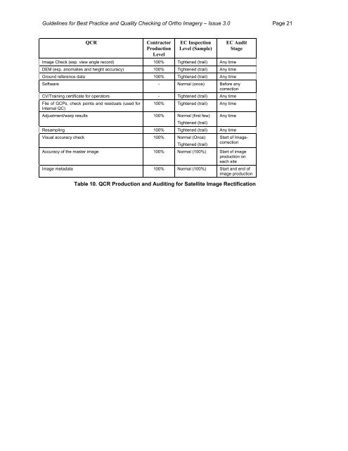
<strong>Guidelines</strong> <strong>for</strong> <strong>Best</strong> <strong>Practice</strong> <strong>and</strong> <strong>Quality</strong> <strong>Checking</strong> <strong>of</strong> <strong>Ortho</strong> <strong>Imagery</strong> – Issue 3.0 Page 21QCRContractorProductionLevelEC InspectionLevel (Sample)EC AuditStageImage Check (esp. view angle record) 100% Tightened (trail) Any timeDEM (esp. anomalies <strong>and</strong> height accuracy) 100% Tightened (trail) Any timeGround reference data 100% Tightened (trail) Any timeS<strong>of</strong>tware - Normal (once) Be<strong>for</strong>e anycorrectionCV/Training certificate <strong>for</strong> operators - Tightened (trail) Any timeFile <strong>of</strong> GCPs, check points <strong>and</strong> residuals (used <strong>for</strong>Internal QC)100% Tightened (trail) Any timeAdjustment/warp results 100% Normal (first few)Tightened (trail)Any timeResampling 100% Tightened (trail) Any timeVisual accuracy check 100% Normal (Once)Tightened (trail)Start <strong>of</strong> ImagecorrectionAccuracy <strong>of</strong> the master image 100% Normal (100%) Start <strong>of</strong> imageproduction oneach siteImage metadata 100% Normal (100%) Start <strong>and</strong> end <strong>of</strong>image productionTable 10. QCR Production <strong>and</strong> Auditing <strong>for</strong> Satellite Image Rectification