Guidelines for Best Practice and Quality Checking of Ortho Imagery
Guidelines for Best Practice and Quality Checking of Ortho Imagery
Guidelines for Best Practice and Quality Checking of Ortho Imagery

You also want an ePaper? Increase the reach of your titles
YUMPU automatically turns print PDFs into web optimized ePapers that Google loves.
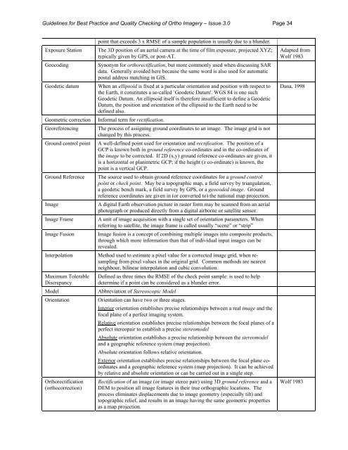
<strong>Guidelines</strong> <strong>for</strong> <strong>Best</strong> <strong>Practice</strong> <strong>and</strong> <strong>Quality</strong> <strong>Checking</strong> <strong>of</strong> <strong>Ortho</strong> <strong>Imagery</strong> – Issue 3.0 Page 34Exposure StationGeocodingGeodetic datumGeometric correctionGeoreferencingGround control pointGround ReferenceImageImage FrameImage FusionInterpolationMaximum TolerableDiscrepancyModelOrientation<strong>Ortho</strong>rectification(orthocorrection)point that exceeds 3 x RMSE <strong>of</strong> a sample population is usually due to a blunder.The 3D position <strong>of</strong> an aerial camera at the time <strong>of</strong> film exposure, projected XYZ;typically given by GPS, or post-AT.Synonym <strong>for</strong> orthorectification, but more commonly used when discussing SARdata. Generally avoided here because the same word is also used <strong>for</strong> automaticpostal address matching in GIS.When an ellipsoid is fixed at a particular orientation <strong>and</strong> position with respect tothe Earth, it constitutes a so-called `Geodetic Datum'. WGS 84 is one suchGeodetic Datum. An ellipsoid itself is there<strong>for</strong>e insufficient to define a GeodeticDatum, the position <strong>and</strong> orientation <strong>of</strong> the ellipsoid to the Earth need to bedefined also.In<strong>for</strong>mal term <strong>for</strong> rectification.The process <strong>of</strong> assigning ground coordinates to an image. The image grid is notchanged by this process.A well-defined point used <strong>for</strong> orientation <strong>and</strong> rectification. The position <strong>of</strong> aGCP is known both in ground reference co-ordinates <strong>and</strong> in the co-ordinates <strong>of</strong>the image to be corrected. If 2D (x,y) ground reference co-ordinates are given, itis a horizontal or planimetric GCP; if the height (z co-ordinate) is known, thepoint is a vertical GCP.The source used to obtain ground reference coordinates <strong>for</strong> a ground controlpoint or check point. May be a topographic map, a field survey by triangulation,a geodetic bench mark, a field survey by GPS, or a geocoded image. Groundreference coordinates are given in (or converted to) the national map projection.A digital Earth observation picture in raster <strong>for</strong>m may be scanned from an aerialphotograph or produced directly from a digital airborne or satellite sensor.A unit <strong>of</strong> image acquisition with a single set <strong>of</strong> orientation parameters. Whenreferring to satellite, the image frame is called usually “scene” or “strip”Image fusion is a concept <strong>of</strong> combining multiple images into composite products,through which more in<strong>for</strong>mation than that <strong>of</strong> individual input images can berevealed.Method used to estimate a pixel value <strong>for</strong> a corrected image grid, when resamplingfrom pixel values in the original grid. Common methods are nearestneighbour, bilinear interpolation <strong>and</strong> cubic convolution.Defined as three times the RMSE <strong>of</strong> the check point sample: is used to helpdetermine if a point can be considered as a blunder error.Abbreviation <strong>of</strong> Stereoscopic ModelOrientation can have two or three stages.Interior orientation establishes precise relationships between a real image <strong>and</strong> thefocal plane <strong>of</strong> a perfect imaging system.Relative orientation establishes precise relationships between the focal planes <strong>of</strong> aperfect stereopair to establish a precise stereomodelAbsolute orientation establishes a precise relationship between the stereomodel<strong>and</strong> a geographic reference system (map projection).Absolute orientation follows relative orientation.Exterior orientation establishes precise relationships between the focal plane coordinates<strong>and</strong> a geographic reference system (map projection). It can be achievedby relative <strong>and</strong> absolute orientation or can be carried out in a single step.Rectification <strong>of</strong> an image (or image stereo pair) using 3D ground reference <strong>and</strong> aDEM to position all image features in their true orthographic locations. Theprocess eliminates displacements due to image geometry (especially tilt) <strong>and</strong>topographic relief, <strong>and</strong> results in an image having the same geometric propertiesas a map projection.Adapted fromWolf 1983Dana, 1998Wolf 1983