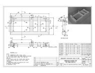
SubSurface Dams - Sustainable Sanitation and Water Management ...
SubSurface Dams - Sustainable Sanitation and Water Management ...
SubSurface Dams - Sustainable Sanitation and Water Management ...

You also want an ePaper? Increase the reach of your titles
YUMPU automatically turns print PDFs into web optimized ePapers that Google loves.
3-4 Surveys carried out in this project3-4-1 Interpretation of satellite images <strong>and</strong> aero-photographsSatellite images <strong>and</strong> aero-photographs are useful means of examining the physical conditions(l<strong>and</strong>form, geology, surface water, vegetation, etc.) of vast areas. They are particularlyvaluable in surveying flat relief areas without precise topographical maps like Africa.In this project, satellite images <strong>and</strong> aero-photographs were interpreted to identify appropriatesites for subsurface dams.(1) L<strong>and</strong>forms considered as appropriate sites for the subsurface damIn the interpretation of satellite images <strong>and</strong> aero-photographs, the following l<strong>and</strong>forms wereconsidered:1) L<strong>and</strong>forms suggesting the potential presence of fossil valleys: These are l<strong>and</strong>formswith excessively wide flood plains, whose line is similar to that of the current rivers(wadis, in many cases), compared with the discharge of current rivers (wadis).2) Ring-shaped l<strong>and</strong>forms: These are l<strong>and</strong>forms whose ridges range in a ring shapewith a gapped part due to denudation. These l<strong>and</strong>forms are often observed in thearea of volcanic rock. Groundwater recharged with rainfall within these l<strong>and</strong>formsconverges at the gapped part.3) Bottleneck-shaped l<strong>and</strong>forms: These are l<strong>and</strong>forms with a bottleneck part of thebasement rock, buried by unconsolidated sediment, possibly accompanied byunderflow water.(2) Procedure for interpretationFirst, false color photographs on a scale of 1/200,000 or 1/500,000 were made fromLANDSAT TM (Thematic Mapper) images covering the central or the northern part ofBurkina Faso. On the basis of the interpretation of these satellite images, 13 sites wereidentified as having potential geomorphological <strong>and</strong> geological structures appropriate for asubsurface dam.Next, preliminary exploration in a large area including these 13 sites was carried out. As aresult, 6 sites were selected, excluding sites with the following problems:- Estimation of the underground structure was difficult, or the scale of the undergroundstructure was too large for the model project.- Access from the capital, Ouagadougou, was too difficult.- Many other projects already existed.Detailed l<strong>and</strong>form classification maps were then drawn from black <strong>and</strong> whiteaero-photographs on a scale of 1/20,000 or 1/50,000 that covered the selected 6 sites. As theresult of this process, 6 sites were narrowed down to 5.It is recommended that aero-photographs be used for the interpretation of limited areasbecause the resolution of the LANDSAT images is low <strong>and</strong> the geomorphological <strong>and</strong>geological structures interpreted from them tend to be biased toward larger ones.(3) Results of the selection of possible sites21