SubSurface Dams - Sustainable Sanitation and Water Management ...
SubSurface Dams - Sustainable Sanitation and Water Management ...
SubSurface Dams - Sustainable Sanitation and Water Management ...

You also want an ePaper? Increase the reach of your titles
YUMPU automatically turns print PDFs into web optimized ePapers that Google loves.
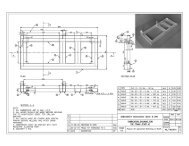
In this project at Nare, the "earth dam" method shown at the bottom of Table 4.1 was adoptedfor the following reasons:1) The "fossil valley" was buried deep (about 8 m below the ground surface), <strong>and</strong> it hadalmost no groundwater run-off in the dry season. It was thus possible to apply thismethod.2) This method does not require sophisticated machines <strong>and</strong> could be carried out withthose available in Burkina Faso.3) The cost of construction, including transportation <strong>and</strong> rental of machines, was thelowest.4-2 Characteristics of the subsurface dam built at NareThe characteristics of the subsurface dam built at Nare for this model project are as follows:(1) SiteIn the fossil valley in the Koulikare Quarter, Nare Village, Tougouri District, NamentengaProvince, Burkina Faso(2) Structure of the dam body"Subsurface earth dam" (see Fig. 4.1)- Depth of the base: 3.0 m to 11.4 m below the ground surface (maximum height of thedam: 8.4 m)- Crest length: 216.3 m- Width (thickness): 8.6 m at the base, 3.0 m at the crest- Volume: 7,144 m 3- Filling materials: clayey silt (heavily weathered layer of basement rock)- Permeability coefficient: 10 -7 to 10 -8 cm/sec (very partly, 10 -6 cm/sec)At the upstream side of the base of the dam, an "anchor key" with about a 3- to 4-m width <strong>and</strong>a 1.5-m depth (protrusion into the basement rock) was formed to protect the base. At a leveljust above the crest, about a 1-m-thick layer of gravel with a similar diameter was laid toensure good permeability.(3) <strong>Water</strong> source of the subsurface dam reservoirShallow groundwater within the fossil valley buried along the Kolongo River, a tributary ofthe Gouaya River that is a part of the Niger River basin(4) Dimensions of reservoir- Maximum extent of reservoir area: 13.4-km length, about 150-m average length(lowest estimate), about 2-km 2 area- Volume of reservoir layer: About 9,000,000 m 3 (estimate)- <strong>Water</strong> storage capacity: About 1,800,000 m 3 (estimate)(5) Amount of construction work-Excavation: Excavation of soil: 51,213 m 3 , excavation of rock: 4,377 m 3 , total:55,590 m 3- High-density filling (the dam body): 7,144 m 337