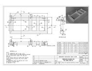
SubSurface Dams - Sustainable Sanitation and Water Management ...
SubSurface Dams - Sustainable Sanitation and Water Management ...
SubSurface Dams - Sustainable Sanitation and Water Management ...

You also want an ePaper? Increase the reach of your titles
YUMPU automatically turns print PDFs into web optimized ePapers that Google loves.
3-4-3 Geophysical surveyAt the 5 sites selected by the interpretation of satellite images <strong>and</strong> aero-photographs <strong>and</strong>preliminary exploration, electric soundings were carried out in addition to field exploration todetermine the geological structure.At some sites in Tangapore Village <strong>and</strong> Nare Village, magnetic soundings were also carriedout, whose results only confirmed those of the electric soundings but with less precision.The electric soundings are thus more useful for detecting underground structure at a shallowdepth.(1) Method of electric soundingsThe electric soundings were carried out using the vertical quadripole method (Wenner’smethod). From their results, resistivity profiles were drawn to analyze the undergroundstructure. One of the resistivity profiles thus obtained is shown in Fig. 3.7.For the electric soundings <strong>and</strong> the analysis of their results, the following points were takeninto account.1) Survey lines for the resistivity profiles, whose length was about 150 to 500 m, wereset across the assumed underground structure. Along the survey lines, the electricsoundings were carried out with an interval of about 50 to 100 m, namely 3 to 10survey points per line.2) At each survey point, a sounding line was drawn parallel to the direction of thesupposed underground structure.3) To obtain a three-dimensional view of the geological structure, 2 to 3 survey lines forthe resistivity profiles were set as far as possible.4) The resistivity of the basement rock (lateritic crust, heavily weathered rock, <strong>and</strong> freshrock) were determined by lengthening the survey lines to an outcrop of basementrock or to a point where basement rock was definitely present at a very shallowdepth. These resistivities determined largely contributed to the geologicalinterpretation of the resistivity profiles.5) Where there were wells (in particular “dug wells”) allowing observation of thegroundwater level <strong>and</strong> geological sections, electric soundings were also carried outnear the wells to determine the resistivity of the well site. These resistivitiesincrease the certainty of the geological interpretation of the resistivity profiles.Resistivity determined by electric soundings reflects not only the electrical properties of therock <strong>and</strong> soil, but also those of the groundwater. Even in the strata composed of identicalmaterials, resistivity may vary remarkably if there is a large difference in their water content.Therefore, resistivity is not sufficient for precisely determining the lithological nature of thestrata. However, resistivities <strong>and</strong> resistivity profiles obtained from electric soundings carriedout at a large number of points are important clues in estimating the geological structure <strong>and</strong>the state of groundwater because zones of almost identical resistivity can be considered tocorrespond to strata with identical lithologies <strong>and</strong> water content.27