SubSurface Dams - Sustainable Sanitation and Water Management ...
SubSurface Dams - Sustainable Sanitation and Water Management ...
SubSurface Dams - Sustainable Sanitation and Water Management ...

You also want an ePaper? Increase the reach of your titles
YUMPU automatically turns print PDFs into web optimized ePapers that Google loves.
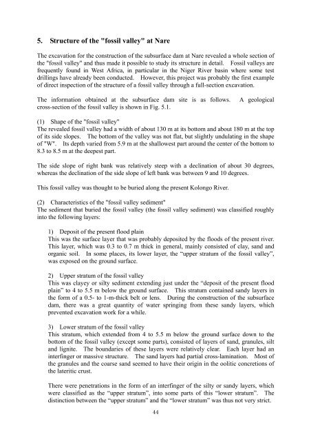
5. Structure of the "fossil valley" at NareThe excavation for the construction of the subsurface dam at Nare revealed a whole section ofthe "fossil valley" <strong>and</strong> thus made it possible to study its structure in detail. Fossil valleys arefrequently found in West Africa, in particular in the Niger River basin where some testdrillings have already been conducted. However, this project was probably the first exampleof direct inspection of the structure of a fossil valley through a full-section excavation.The information obtained at the subsurface dam site is as follows. A geologicalcross-section of the fossil valley is shown in Fig. 5.1.(1) Shape of the "fossil valley"The revealed fossil valley had a width of about 130 m at its bottom <strong>and</strong> about 180 m at the topof its side slopes. The bottom of the valley was not flat, but slightly undulating in the shapeof "W". Its depth varied from 5.9 m at the shallowest part around the center of the bottom to8.3 to 8.5 m at the deepest part.The side slope of right bank was relatively steep with a declination of about 30 degrees,whereas the declination of the side slope of left bank was between 9 <strong>and</strong> 10 degrees.This fossil valley was thought to be buried along the present Kolongo River.(2) Characteristics of the "fossil valley sediment"The sediment that buried the fossil valley (the fossil valley sediment) was classified roughlyinto the following layers:1) Deposit of the present flood plainThis was the surface layer that was probably deposited by the floods of the present river.This layer, which was 0.3 to 0.7 m thick in general, mainly consisted of clay, s<strong>and</strong> <strong>and</strong>organic soil. In some places, its lower layer, the “upper stratum of the fossil valley”,was exposed on the ground surface.2) Upper stratum of the fossil valleyThis was clayey or silty sediment extending just under the “deposit of the present floodplain” to 4 to 5.5 m below the ground surface. This stratum contained s<strong>and</strong>y layers inthe form of a 0.5- to 1-m-thick belt or lens. During the construction of the subsurfacedam, there was a great quantity of water springing from these s<strong>and</strong>y layers, whichprevented excavation work for a while.3) Lower stratum of the fossil valleyThis stratum, which extended from 4 to 5.5 m below the ground surface down to thebottom of the fossil valley (except some parts), consisted of layers of s<strong>and</strong>, granules, silt<strong>and</strong> lignite. The boundaries of these layers were relatively clear. Each layer had aninterfinger or massive structure. The s<strong>and</strong> layers had partial cross-lamination. Most ofthe granules <strong>and</strong> the coarse s<strong>and</strong> seemed to have their origin in the oolitic concretions ofthe lateritic crust.There were penetrations in the form of an interfinger of the silty or s<strong>and</strong>y layers, whichwere classified as the “upper stratum”, into some parts of this “lower stratum”. Thedistinction between the “upper stratum” <strong>and</strong> the “lower stratum” was thus not very strict.44