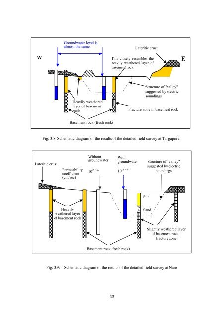
Groundwater level isalmost the same.Lateritic crustWThis closely resembles theheavily weathered layer ofbasement rock.EHeavily weatheredlayer of basementrockStructure of "valley"suggested by electricsoundingsFracture zone in basement rockBasement rock (fresh rock)Fig. 3.8: Schematic diagram of the results of the detailed field survey at TangaporeLateritic crustPermeabilitycoefficient(cm/sec)Without Withgroundwater groundwater10 -5 ~ -6 10 -3 ~ -4Structure of "valley"suggested by electricsoundingsSiltHeavilyweathered layerof basement rockS<strong>and</strong>Slightly weathered layerof basement rock -fracture zoneBasement rock (fresh rock)Fig. 3.9:Schematic diagram of the results of the detailed field survey at Nare33
3-6 Socio-economic studyAs a part of the field survey, a socio-economic study was also carried out at Tangapore <strong>and</strong>Nare.A summary of the results of the study is as follows:Tangapore- Population: 2,079, all Mossi people- Public services: One primary school (built in 1995), no dispensary- Main activities for living: Agriculture, with livestock farming as secondary.Commerce is also active in the market (Korsimoro).- Common diseases: Meningitis, eye diseases, headaches, tumors, diarrhea, etc.- Annual average rainfall: About 660 mm until 1995The village is located in the transition zone between low mountains <strong>and</strong> peneplain. Not onlythe peneplain but also the gentle mountain slope are cultivated, <strong>and</strong> the arable l<strong>and</strong> isexploited almost to the limit. Due to the use of fertilizers in some parts, the foodself-sufficiency rate is estimated to be more than 90%. However, considering the situationthat no more arable l<strong>and</strong> remains <strong>and</strong> the l<strong>and</strong> has continued to degrade, the village is likely tosuffer serious food shortage with the increase in population in the near future. It is thusprimarily important to increase the productivity of the l<strong>and</strong>, <strong>and</strong> to exploit new waterresources for it.Livestock farming is the secondary activity for living in this village, <strong>and</strong> has a role of"savings" to prepare for emergency situations such as drought. However, a shortage ofpasture <strong>and</strong> a lack of water for animals in the dry season are problems for this activity.There were 3 h<strong>and</strong> pumps, 6 dug wells, 1 small-scale surface dam <strong>and</strong> 6 reservoirs in thevillage, but it was estimated that only about 70% of the water dem<strong>and</strong> (about 20 liters perperson) for domestic use was supplied. The water in the small-scale surface dam <strong>and</strong>reservoirs used by livestock animals was also used by the villagers for domestic use, <strong>and</strong> thissituation led to diseases caused by polluted water. Therefore, to improve water quality fordomestic use, the exploitation of new water resources was necessary.Some young villagers in Tangapore had formed a group to undertake the modernization ofagriculture, <strong>and</strong> they were trying to produce compost <strong>and</strong> to grow some vegetables.Tree-planting education was also promoted in the primary school. Although the lack ofwater constrained these activities, the will, experience <strong>and</strong> recognition of the villagers willfacilitate their participation in this project that will aim mainly at the effective use ofgroundwater resources.Nare- Population: 2,896, mostly Mossi people with some Fulani people- Public services: One primary school (built in 1996), no dispensary- Main activities for living: Agriculture, with livestock farming as secondary (It is theprincipal activity for Fulani people.)- Common diseases: Guinea worm infections, eye diseases, dysentery, meningitis, etc.- Annual average rainfall: About 590 mm until 199534