Using Rotations to Build Aerospace Coordinate Systems - Defence ...
Using Rotations to Build Aerospace Coordinate Systems - Defence ...
Using Rotations to Build Aerospace Coordinate Systems - Defence ...

You also want an ePaper? Increase the reach of your titles
YUMPU automatically turns print PDFs into web optimized ePapers that Google loves.
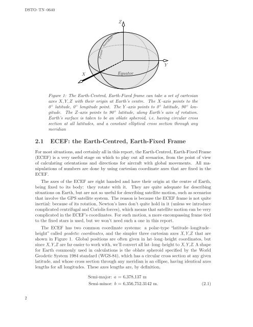
DSTO–TN–0640ZmeridianPrimeYXEqua<strong>to</strong>rFigure 1: The Earth-Centred, Earth-Fixed frame can take a set of cartesianaxes X, Y, Z with their origin at Earth’s centre. The X-axis points <strong>to</strong> the0 ◦ latitude, 0 ◦ longitude point. The Y -axis points <strong>to</strong> 0 ◦ latitude, 90 ◦ longitude.The Z-axis points <strong>to</strong> 90 ◦ latitude, along Earth’s axis of rotation.Earth’s surface is taken <strong>to</strong> be an oblate spheroid, i.e. having circular crosssection at all latitudes, and a constant elliptical cross section through anymeridian2.1 ECEF: the Earth-Centred, Earth-Fixed FrameFor most situations, and certainly all in this report, the Earth-Centred, Earth-Fixed Frame(ECEF) is a very useful stage on which <strong>to</strong> play out all scenarios, from the point of viewof calculating orientations and directions for aircraft with global movements. All manipulationsof numbers are done by using cartesian coordinate axes that are fixed in theECEF.The axes of the ECEF are right handed and have their origin at the centre of Earth,being fixed <strong>to</strong> its body: they rotate with it. They are quite adequate for describingsituations on Earth, but are not so useful for describing satellite motion, such as scenariosthat involve the GPS satellite system. The reason is because the ECEF frame is not quiteinertial: because of its rotation, New<strong>to</strong>n’s laws don’t quite hold in it (unless we introducecomplicated centrifugal and Coriolis forces), which means that satellite motion can be verycomplicated in the ECEF’s coordinates. For such motion, a more encompassing frame tied<strong>to</strong> the fixed stars is used, but we won’t need such a one in this report.The ECEF has two common coordinate systems: a polar-type “latitude–longitude–height” called geodetic coordinates, and the simpler three cartesian axes X,Y,Z that areshown in Figure 1. Global positions are often given in lat–long–height coordinates, butsince X,Y,Z are far easier <strong>to</strong> work with, we’ll convert all lat–long–height <strong>to</strong> X,Y,Z. A shapefor Earth commonly used in calculations is the oblate spheroid specified by the WorldGeodetic System 1984 standard (WGS-84), which has a circular cross section at any givenlatitude, and whose cross section through any meridian is an ellipse, having identical axeslengths for all longitudes. These axes lengths are, by definition,Semi-major: a = 6,378,137 mSemi-minor: b = 6,356,752.3142 m. (2.1)2