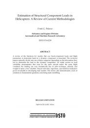
DSTO–TN–0640ZNDEN 0E 0D 0 N 1E 1ωαYXD 1Figure 5: Constructing local north–east–down axes N, E, D at a given poin<strong>to</strong>f known latitude and longitude. Start with the three vec<strong>to</strong>rs N 0 , E 0 , D 0 .Construct the intermediate set N 1 , E 1 , D 1 by rotating the original setthrough the longitude ω about N 0 . Then rotate N 1 , E 1 , D 1 about −E 1 by thelatitude α, according <strong>to</strong> the right hand rule, <strong>to</strong> give the final set N, E, D. Orequivalently, rotate the intermediate set about E 1 through minus the latitude.The resulting vec<strong>to</strong>rs are the local north–east–down axesthe act of rotating each of the vec<strong>to</strong>rs that represent the axes of some frame.There are two basic tasks <strong>to</strong> consider in this type of aerospace calculation. First, givena place on Earth (usually in lat–long–height coordinates), we need <strong>to</strong> construct the localgeographic frame’s axes, such as NED. Second, an aircraft can be introduced in<strong>to</strong> thisNED frame, and its orientation found relative <strong>to</strong> that frame.4.1 Constructing NED Axes for the Local Geographic FrameGiven the lat–long–height of a place on or near Earth, the first thing we wish <strong>to</strong> do is findthe local NED axes. The technique used is the primary one of this report. We build aninitial set of NED axes in a place where it’s simple <strong>to</strong> determine them, and then we rotatethese around <strong>to</strong> the required place.The simplest place <strong>to</strong> construct an initial set of NED axes is on the junction of theEqua<strong>to</strong>r and the prime meridian, since this has a latitude and longitude of α = ω = 0 ◦ .Represent each axis by a unit vec<strong>to</strong>r in the ECEF frame, which all calculations are beingdone within:⎡ ⎤0⎡ ⎤0⎡ ⎤−1N 0 = ⎣0⎦ , E 0 = ⎣1⎦ , D 0 = ⎣ 0⎦ . (4.1)1 0 0The scenario is shown in Figure 5. Now rotate each of the N 0 , E 0 , D 0 vec<strong>to</strong>rs in two steps.12
DSTO–TN–0640The first rotation is about the N 0 vec<strong>to</strong>r by the longitude ω, taking care <strong>to</strong> realise thatthe rotation matrix will obey the right hand rule. This rotation creates an intermediatetriplet of vec<strong>to</strong>rs, taking N 0 →N 1 , E 0 →E 1 , D 0 →D 1 . (Of course, N 1 = N 0 , but forclarity we keep each triplet <strong>to</strong>gether notationally.)Now rotate each of the intermediate set by the latitude α about −E 1 ; again we’ve beencareful <strong>to</strong> note the use of the right hand rule, so need <strong>to</strong> specify the axis of rotation as −E 1 .(We can certainly use +E 1 , but will have <strong>to</strong> rotate by −α about this. The rotation matrixor quaternion will be unchanged.) Because the original N 0 , E 0 , D 0 vec<strong>to</strong>rs each haveunit length, they au<strong>to</strong>matically satisfy the requirement for the axis vec<strong>to</strong>r n <strong>to</strong> be of unitlength in (3.7). Notice that the clever way that latitude has been defined means we needn’tworry that Earth’s shape is not spherical; two places separated by say 50 ◦ latitude on thesame meridian will certainly have a 50 ◦ angle between their North vec<strong>to</strong>rs, and a 50 ◦ anglebetween their Down vec<strong>to</strong>rs.The sequence of steps is:N 1 = R N0(ω)N 0 = N 0E 1 = R N0(ω)E 0D 1 = R N0(ω)D 0N = R −E1(α)N 1E = R −E1(α)E 1 = E 1D = R −E1(α)D 1 . (4.2)The resulting vec<strong>to</strong>rs N, E, D are the local north–east–down axes, and can be used forfurther calculations. In the interest of pedagogy, we have made the steps as alike aspossible, but in practice they can be heavily reduced <strong>to</strong>E = R N0(ω)E 0N = R −E(α)N 0D = N × E . (4.3)This reduction is purely a question of pedagogy versus computational speed. Equations(4.2) allow for a step by step follow-through of the process, which is useful forwriting transparent computer code or debugging in more complicated situations wheremore than two rotations need <strong>to</strong> be performed. In this two-rotation case, it’s certainly notdifficult <strong>to</strong> use (4.3) without having <strong>to</strong> think along the lines of (4.2) at all. But situationsrequiring more than two rotations will not be so easily abbreviated.The following example draws many of these ideas <strong>to</strong>gether.Example: If we are in Adelaide and Earth is transparent, what is the compass bearing ofBrussels if we are looking straight at it through Earth?We’ll calculate ECEF position vec<strong>to</strong>rs of both Adelaide and Brussels, subtracting onefrom the other <strong>to</strong> find the position vec<strong>to</strong>r of Brussels relative <strong>to</strong> Adelaide, and then expressthis in the local NED axes at Adelaide using dot products. It’s helpful <strong>to</strong> write the vec<strong>to</strong>rsin the following way, where A = Adelaide, B = Brussels, and C = some other useful point.13