
Create successful ePaper yourself
Turn your PDF publications into a flip-book with our unique Google optimized e-Paper software.
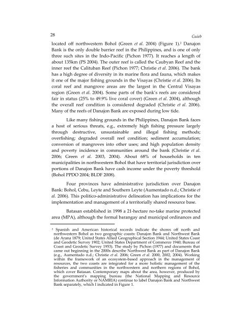
28Guieblocated off northwestern Bohol (Green et al. 2004) (Figure 1). 2 DanajonBank is the only double barrier reef in the Philippines, and is one of onlythree such sites in the Indo-Pacific (Pichon 1977). It reaches a length ofabout 135km (PS 2004). The outer reef is called the Caubyan Reef and theinner reef the Calituban Reef (Pichon 1977; Christie et al. 2006). The bankhas a high degree of diversity in its marine flora and fauna, which makesit one of the major fishing grounds in the Visayas (Christie et al. 2006). Itscoral reef and mangrove areas are the largest in the Central Visayasregion (Green et al. 2004). Some parts of the bank’s reefs are consideredfair in status (25% to 49.9% live coral cover) (Green et al. 2004), althoughthe overall reef condition is considered degraded (Christie et al. 2006).Many of the reefs of Danajon Bank are exposed during low tide.Like many fishing grounds in the Philippines, Danajon Bank facesa host of serious threats, e.g., extremely high fishing pressure largelythrough destructive, unsustainable and illegal fishing methods;overfishing; degraded overall reef condition; sediment accumulation;conversion of mangroves into other uses; and high population densityand poverty incidence in communities around the bank (Christie et al.2006; Green et al. 2003, 2004). About 68% of households in tenmunicipalities in northwestern Bohol that have territorial jurisdiction overportions of Danajon Bank have cash income under the poverty threshold(Bohol PPDO 2004; BLDF 2008).Four provinces have administrative jurisdiction over DanajonBank: Bohol, Cebu, Leyte and Southern Leyte (Aumentado n.d.; Christie etal. 2006). This politico-administrative delineation has implications for theimplementation and management of a territorially shared resource base.Batasan established in 1998 a 21-hectare no-take marine protectedarea (MPA), although the formal barangay and municipal ordinances and2Spanish and American historical records indicate the shores off north andnorthwestern Bohol as two geographic coasts: Danajon Bank and Northwest Bank(de Arana 1879; United States Allied Geographical Section 1944; United States Coastand Geodetic Survey 1902; United States Department of Commerce 1940; Bureau ofCoast and Geodetic Survey 1953). The study by Pichon (1977) and documents thatcame out beginning in the 2000s describe Northwest Bank as part of Danajon Bank(e.g., Aumentado n.d.; Christie et al. 2006; Green et al. 2000, 2002, 2004). Workingwithin the framework of an ecosystem-based approach in the management ofresources, the two coasts are integrated for a more holistic management of thefisheries and communities in the northwestern and northern regions of Bohol,which cover Batasan. Contemporary maps about the area, however, produced bythe government’s mapping bureau (the National Mapping and ResourceInformation Authority or NAMRIA) continue to label Danajon Bank and NorthwestBank separately, which I indicated in Figure 1.