Action Plan for the Town of Chatham Ponds
rev 3a report.pdf - Town to Chatham
rev 3a report.pdf - Town to Chatham

Create successful ePaper yourself
Turn your PDF publications into a flip-book with our unique Google optimized e-Paper software.
defined as DO < 1 mg/l) phosphorus adsorbed to <strong>the</strong> lake bottom sediments become soluble and<br />
diffuses into <strong>the</strong> overlying water. As ponds become more productive, anoxia is measured higher<br />
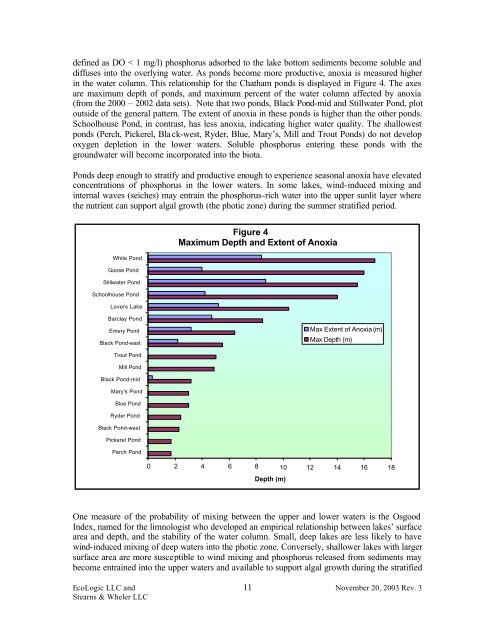
in <strong>the</strong> water column. This relationship <strong>for</strong> <strong>the</strong> <strong>Chatham</strong> ponds is displayed in Figure 4. The axes<br />
are maximum depth <strong>of</strong> ponds, and maximum percent <strong>of</strong> <strong>the</strong> water column affected by anoxia<br />
(from <strong>the</strong> 2000 – 2002 data sets). Note that two ponds, Black Pond-mid and Stillwater Pond, plot<br />
outside <strong>of</strong> <strong>the</strong> general pattern. The extent <strong>of</strong> anoxia in <strong>the</strong>se ponds is higher than <strong>the</strong> o<strong>the</strong>r ponds.<br />
Schoolhouse Pond, in contrast, has less anoxia, indicating higher water quality. The shallowest<br />
ponds (Perch, Pickerel, Black-west, Ryder, Blue, Mary’s, Mill and Trout <strong>Ponds</strong>) do not develop<br />
oxygen depletion in <strong>the</strong> lower waters. Soluble phosphorus entering <strong>the</strong>se ponds with <strong>the</strong><br />
groundwater will become incorporated into <strong>the</strong> biota.<br />
<strong>Ponds</strong> deep enough to stratify and productive enough to experience seasonal anoxia have elevated<br />
concentrations <strong>of</strong> phosphorus in <strong>the</strong> lower waters. In some lakes, wind-induced mixing and<br />
internal waves (seiches) may entrain <strong>the</strong> phosphorus-rich water into <strong>the</strong> upper sunlit layer where<br />
<strong>the</strong> nutrient can support algal growth (<strong>the</strong> photic zone) during <strong>the</strong> summer stratified period.<br />
White Pond<br />
Goose Pond<br />
Stillwater Pond<br />
Schoolhouse Pond<br />
Lovers Lake<br />
Figure 4<br />
Maximum Depth and Extent <strong>of</strong> Anoxia<br />
Barclay Pond<br />
Emery Pond<br />
Black Pond-east<br />
Max Extent <strong>of</strong> Anoxia (m)<br />
Max Depth (m)<br />
Trout Pond<br />
Mill Pond<br />
Black Pond-mid<br />
Mary's Pond<br />
Blue Pond<br />
Ryder Pond<br />
Black Pond-west<br />
Pickerel Pond<br />
Perch Pond<br />
0 2 4 6 8 10 12 14 16 18<br />
Depth (m)<br />
One measure <strong>of</strong> <strong>the</strong> probability <strong>of</strong> mixing between <strong>the</strong> upper and lower waters is <strong>the</strong> Osgood<br />
Index, named <strong>for</strong> <strong>the</strong> limnologist who developed an empirical relationship between lakes’ surface<br />
area and depth, and <strong>the</strong> stability <strong>of</strong> <strong>the</strong> water column. Small, deep lakes are less likely to have<br />
wind-induced mixing <strong>of</strong> deep waters into <strong>the</strong> photic zone. Conversely, shallower lakes with larger<br />
surface area are more susceptible to wind mixing and phosphorus released from sediments may<br />
become entrained into <strong>the</strong> upper waters and available to support algal growth during <strong>the</strong> stratified<br />
EcoLogic LLC and 11<br />
November 20, 2003 Rev. 3<br />
Stearns & Wheler LLC