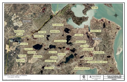
<strong>Action</strong> <strong>Plan</strong> <strong>for</strong> <strong>the</strong> <strong>Town</strong> <strong>of</strong> <strong>Chatham</strong> <strong>Ponds</strong> 1. Introduction and Scope This report summarizes <strong>the</strong> water quality and aquatic habitat conditions <strong>of</strong> <strong>the</strong> freshwater ponds <strong>of</strong> <strong>Chatham</strong>, and recommends measures <strong>for</strong> protection and restoration <strong>of</strong> this valuable resource. Twenty inland ponds are included in this report; <strong>the</strong> ponds range in size from 0.5 to 16.7 ha (1.2 – 41 acres) and are used <strong>for</strong> aes<strong>the</strong>tic enjoyment, recreational fishing, swimming, and boating. In July 2003, Ecologic and Stearns & Wheler entered into an agreement with <strong>the</strong> <strong>Town</strong> to develop an action plan <strong>for</strong> protecting and restoring <strong>the</strong> nutrient-related water quality <strong>of</strong> a total <strong>of</strong> 17 freshwater ponds <strong>of</strong> <strong>Chatham</strong>. An additional three ponds, Minister’s Pond, Fox Pond, and Cranberry (a flooded bog), were added to <strong>the</strong> original scope at <strong>the</strong> request <strong>of</strong> Dr. Robert Duncanson <strong>of</strong> <strong>the</strong> <strong>Town</strong> <strong>of</strong> <strong>Chatham</strong> Water Quality Laboratory during <strong>the</strong> site visit <strong>of</strong> July 15, 2003. The site visit was an opportunity to complete a visual assessment <strong>of</strong> habitat quality and land use in <strong>the</strong> ponds’ watersheds. The location <strong>of</strong> <strong>the</strong> ponds within <strong>the</strong> <strong>Town</strong> <strong>of</strong> <strong>Chatham</strong> is illustrated in Figure 1. We used existing data describing water quality and aquatic habitat conditions within <strong>the</strong> ponds, drawing on <strong>the</strong> characterization published in <strong>the</strong> Cape Cod Pond and Lake Atlas <strong>for</strong> eight <strong>of</strong> <strong>the</strong> ponds (Cape Cod Commission Water Resources Office, May 2003). These data were complemented by additional data available from <strong>the</strong> <strong>Town</strong> <strong>of</strong> <strong>Chatham</strong> Water Quality Laboratory including results <strong>of</strong> <strong>the</strong> 2001 and 2002 monitoring program. In addition, we reviewed <strong>the</strong> findings <strong>of</strong> <strong>the</strong> qualitative Pond Shoreline Survey Report (Horsley & Witten, February 2003) developed <strong>for</strong> several ponds in <strong>the</strong> Pleasant Bay Watershed. Stearns & Wheler provided a series <strong>of</strong> GIS land use maps. This report defines potential options <strong>for</strong> protection and improvement <strong>of</strong> <strong>the</strong> freshwater ponds <strong>of</strong> <strong>Chatham</strong> and develops a set <strong>of</strong> specific recommendations. The recommendations reflect our assessment <strong>of</strong> effectiveness (both short-term and long-term), cost, permitting issues, and recreational impacts. The recommended actions include institutional, technical, and public education components. Some recommendations are town-wide, while o<strong>the</strong>rs are directed to specific ponds. An overall implementation strategy is presented that defines priority actions and sequencing <strong>of</strong> recommendations. 2. Nutrients and Eutrophication “Lakes seem, on <strong>the</strong> scale <strong>of</strong> years or human life spans, permanent features <strong>of</strong> <strong>the</strong> landscape, but <strong>the</strong>y are geologically transitory, usually born <strong>of</strong> catastrophe and mature and die quietly and imperceptibly” (Hutchinson 1957). This <strong>of</strong>ten-cited quote from a classic limnology text provides excellent context <strong>for</strong> reviewing <strong>the</strong> current and future conditions <strong>of</strong> <strong>the</strong> ponds <strong>of</strong> <strong>Chatham</strong>. The ponds may be arrayed along a continuum from open, clear, water with little visible algal growth to extremely shallow, productive systems well on <strong>the</strong>ir way to becoming wetlands (Figure 2). Eutrophication, <strong>the</strong> term <strong>for</strong> both <strong>the</strong> process and <strong>the</strong> effects <strong>of</strong> enrichment <strong>of</strong> surface water systems (including lakes, ponds, estuaries, and reservoirs), is a major water quality issue. As aquatic systems become increasingly enriched with plant nutrie nts, organic matter, and silt <strong>the</strong> EcoLogic LLC and 1 November 20, 2003 Rev. 3 Stearns & Wheler LLC
FOX POND HARWICH STILLWATER POND MINISTER'S POND TROUT POND PINKWINK POND CRANBERRY POND MILL POND PICKEREL POND LOVERS LAKE SCHOOLHOUSE POND BARCLAY'S POND CHATHAM LITTLE POND EMERY POND DUANE POND BLACK POND MID GOOSE POND MARY'S POND BLACK POND EAST SOUTH POND RYDER'S POND BLUE POND WHITE POND PERCH POND ARCHIES POND BLACK POND WEST CHRISTOPHER HARDING LANE POND BEARSES POND MEADOW VIEW ROAD POND Data Source: MassGIS .5 Meter Color Orthophoto 1 inch equals 1,500 feet File Location: D:\GIS Project Folder\Job#\<strong>Chatham</strong>\Freshwater <strong>Ponds</strong>.mxd Hyannis, Massachusetts <strong>Town</strong> <strong>of</strong> <strong>Chatham</strong>, MA FRESHWATER PONDS 11/19/03 FIGURE 1