Part 1 – A Rapid Participatory Biodiversity Assessment - IUCN
Part 1 – A Rapid Participatory Biodiversity Assessment - IUCN
Part 1 – A Rapid Participatory Biodiversity Assessment - IUCN
You also want an ePaper? Increase the reach of your titles
YUMPU automatically turns print PDFs into web optimized ePapers that Google loves.
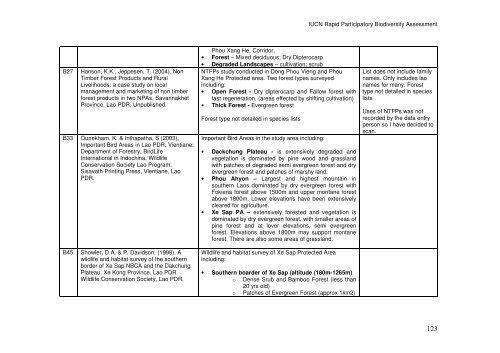
B27 Hanson, K.K., Jeppesen, T. (2004), Non<br />
Timber Forest Products and Rural<br />
Livelihoods: a case study on local<br />
management and marketing of non timber<br />
forest products in two NPAs, Savannakhet<br />
Province, Lao PDR, Unpublished.<br />
B33 Ounekham, K. & Inthapatha, S (2003),<br />
Important Bird Areas in Lao PDR, Vientiane:<br />
Department of Forestry, BirdLife<br />
International in Indochina, Wildlife<br />
Conservation Society Lao Program,<br />
Sisavath Printing Press, Vientiane, Lao<br />
PDR.<br />
B45 Showler, D.A. & P. Davidson. (1998). A<br />
wildlife and habitat survey of the southern<br />
border of Xe Sap NBCA and the Dakchung<br />
Plateau, Xe Kong Province, Lao PDR.<br />
Wildlife Conservation Society, Lao PDR.<br />
Phou Xang He, Corridor.<br />
• Forest <strong>–</strong> Mixed deciduous; Dry Dipterocarp<br />
• Degraded Landscapes <strong>–</strong> cultivation; scrub<br />
NTFPs study conducted in Dong Phou Vieng and Phou<br />
Xang He Protected area. Two forest types surveyed<br />
including:<br />
• Open Forest - Dry dipterocarp and Fallow forest with<br />
fast regeneration. (areas effected by shifting cultivation)<br />
• Thick Forest - Evergreen forest<br />
Forest type not detailed in species lists<br />
Important Bird Areas in the study area including:<br />
• Dackchung Plateau - is extensively degraded and<br />
vegetation is dominated by pine wood and grassland<br />
with patches of degraded semi evergreen forest and dry<br />
evergreen forest and patches of marshy land.<br />
• Phou Ahyon <strong>–</strong> Largest and highest mountain in<br />
southern Laos dominated by dry evergreen forest with<br />
Fokiena forest above 1500m and upper montane forest<br />
above 1800m. Lower elevations have been extensively<br />
cleared for agriculture.<br />
• Xe Sap PA <strong>–</strong> extensively forested and vegetation is<br />
dominated by dry evergreen forest, with smaller areas of<br />
pine forest and at lover elevations, semi evergreen<br />
forest. Elevations above 1800m may support montane<br />
forest. There are also some areas of grassland.<br />
Wildlife and habitat survey of Xe Sap Protected Area<br />
including:<br />
• Southern boarder of Xe Sap (altitude (180m-1265m)<br />
o Dense Srub and Bamboo Forest (less than<br />
20 yrs old)<br />
o Patches of Evergreen Forest (approx 1km2)<br />
<strong>IUCN</strong> <strong>Rapid</strong> <strong>Part</strong>icipatory <strong>Biodiversity</strong> <strong>Assessment</strong><br />
List does not include family<br />
names. Only includes lao<br />
names for many. Forest<br />
type not detailed in species<br />
lists<br />
Uses of NTFPs was not<br />
recorded by the data entry<br />
person so I have decided to<br />
scan.<br />
123


