


Create successful ePaper yourself
Turn your PDF publications into a flip-book with our unique Google optimized e-Paper software.
4. 4BPOINTS, LINES AND POLYGONS - VECTOR DATA BASICS.<br />
<strong>QGIS</strong> <strong>for</strong> <strong>Archaeologists</strong> <strong>–</strong> A <strong>Basic</strong> <strong>Guide</strong><br />
Vector data is a representation of the real world using points, lines and polygons. In archaeology this<br />
might include find-spots or sites on a regional distribution map, rivers or other linear features in the<br />
landscape or the edges of cut features, spreads of material or cobbled surfaces.<br />
To illustrate how to manipulate vector data, we’ll need to find a source to start with.<br />
1) Point your browser towards:<br />
https://www.ordnancesurvey.co.uk/opendatadownload/products.html<br />
2) Scroll down the screen until you find Boundary Line, tick the download box and scroll down to<br />
click the next button. Fill in your details and await the link which will be sent via email...<br />
3) Click on the download link, and wait <strong>for</strong> the zip file to appear.<br />
4) While it’s downloading, CREATE YOUR FOLDER ARCHITECTURE. Make a new folder and call it Sutton<br />
Hoo. Within the Sutton Hoo folder, create another folder called Sutton Hoo Vector Data.<br />
5) Back in <strong>QGIS</strong> click SAVE AS.<br />
6) Save the project as Sutton Hoo in the [Sutton Hoo] Folder and make sure that file paths are set to<br />
relative, on the fly CRS trans<strong>for</strong>mation is checked, and the project CRS is set to OSGB36 [27700].<br />
4.1. 16BImporting polylines<br />
Open the Boundary Line file, open the DATA folder, then the GB folder and select ALL the FILES 1<br />
which are named high_water_polyline. Drag and drop these files into Sutton Hoo Vector Data.<br />
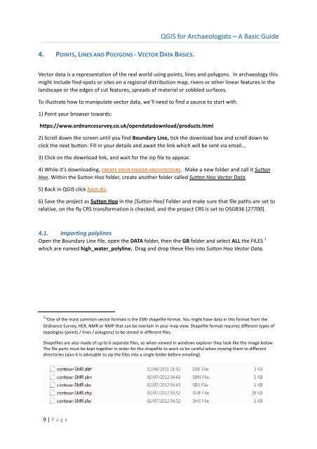
1 “One of the most common vector <strong>for</strong>mats is the ESRI shapefile <strong>for</strong>mat. You might have data in this <strong>for</strong>mat from the<br />
Ordnance Survey, HER, NMR or NMP that can be overlain in your map view. Shapefile <strong>for</strong>mat requires different types of<br />
topologies (points / lines / polygons) to be stored in different files.<br />
Shapefiles are also made of up to 6 separate files, so when viewed in windows explorer they look like the image below.<br />
The file parts must be kept together in order <strong>for</strong> the shapefile to work so be careful when moving them to different<br />
directories (also it is advisable to zip the files into a single folder be<strong>for</strong>e emailing).<br />
9 | P age