


Create successful ePaper yourself
Turn your PDF publications into a flip-book with our unique Google optimized e-Paper software.
10. 24LIDAR 2 <strong>–</strong> AN EXERCISE IN WORKING WITH THE DATA<br />
<strong>QGIS</strong> <strong>for</strong> <strong>Archaeologists</strong> <strong>–</strong> A <strong>Basic</strong> <strong>Guide</strong><br />
10.1. Using a raster catalogue<br />
For the following exercise, let’s actually add something to the archaeological record. Start a new<br />
<strong>QGIS</strong> project in a new project folder.<br />
1) Name the project “Dales Lidar”, make sure that the working coordinate reference system is<br />
OSGB1936 [27700] and the file paths are relative. .<br />
We’re going to head to the Yorkshire Dales, where there’s some 1m resolution Lidar data, which we<br />
can use to spot archaeological sites such as earthworks and field systems. I’ll also introduce a new<br />
technique called de-trending which will help to reduce the amount of background noise from very<br />
hilly terrain.<br />
2) Head back to the Environment Agency website and download the composite Digital Terrain Model<br />
<strong>for</strong> map square SD 87.<br />
3) Once you’ve got it downloaded, extract the tiles into a suitably named sub-folder in the project<br />
folder<br />
There’s a lot of tiles - importing them all<br />
individually is a really bad idea, as you’ll<br />
have to go around changing the CRS <strong>for</strong><br />
each individual hectare tile and that will<br />
drive you mad, as well as taking hours!<br />
You can avoid this by changing the CRS<br />
preferences in Settings > CRS<br />
Also, there will be noticeable breaks<br />
around the edges of each tile, as each<br />
one will have its own histogram,<br />
controlling how black and white each<br />
pixel is rendered.<br />
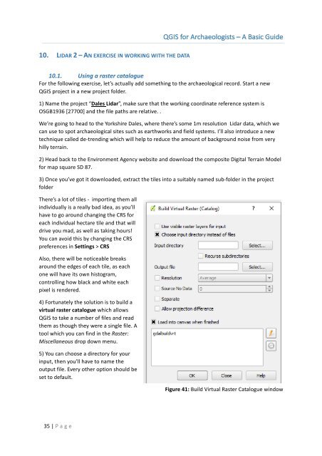
4) Fortunately the solution is to build a<br />
virtual raster catalogue which allows<br />
<strong>QGIS</strong> to take a number of files and read<br />
them as though they were a single file. A<br />
tool which you can find in the Raster:<br />
Miscellaneous drop down menu.<br />
5) You can choose a directory <strong>for</strong> your<br />
input, then you’ll have to name the<br />
output file. Every other option should be<br />
set to default.<br />
Figure 41: Build Virtual Raster Catalogue window<br />
35 | P age