


Create successful ePaper yourself
Turn your PDF publications into a flip-book with our unique Google optimized e-Paper software.
<strong>QGIS</strong> <strong>for</strong> <strong>Archaeologists</strong> <strong>–</strong> A <strong>Basic</strong> <strong>Guide</strong><br />
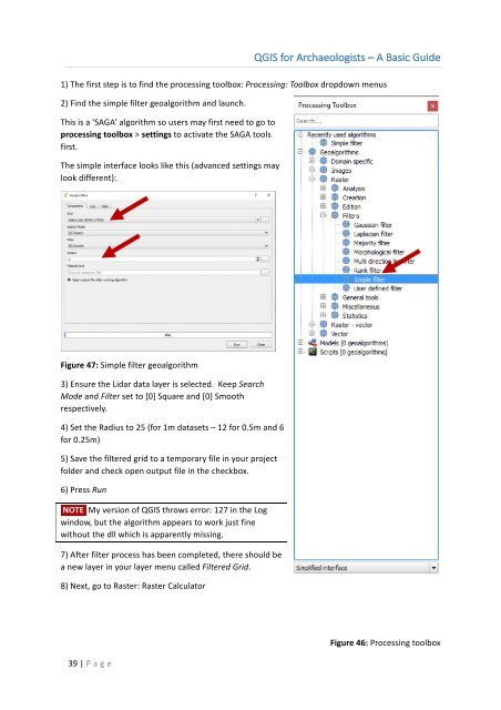
1) The first step is to find the processing toolbox: Processing: Toolbox dropdown menus<br />
2) Find the simple filter geoalgorithm and launch.<br />
This is a ‘SAGA’ algorithm so users may first need to go to<br />
processing toolbox > settings to activate the SAGA tools<br />
first.<br />
The simple interface looks like this (advanced settings may<br />
look different):<br />
Figure 47: Simple filter geoalgorithm<br />
3) Ensure the Lidar data layer is selected. Keep Search<br />
Mode and Filter set to [0] Square and [0] Smooth<br />
respectively.<br />
4) Set the Radius to 25 (<strong>for</strong> 1m datasets <strong>–</strong> 12 <strong>for</strong> 0.5m and 6<br />
<strong>for</strong> 0.25m)<br />
5) Save the filtered grid to a temporary file in your project<br />
folder and check open output file in the checkbox.<br />
6) Press Run<br />
NOTE My version of <strong>QGIS</strong> throws error: 127 in the Log<br />
window, but the algorithm appears to work just fine<br />
without the dll which is apparently missing.<br />
7) After filter process has been completed, there should be<br />
a new layer in your layer menu called Filtered Grid.<br />
8) Next, go to Raster: Raster Calculator<br />
39 | P age<br />
Figure 46: Processing toolbox