Oceans of noise - Whale and Dolphin Conservation Society
Oceans of noise - Whale and Dolphin Conservation Society
Oceans of noise - Whale and Dolphin Conservation Society

Create successful ePaper yourself
Turn your PDF publications into a flip-book with our unique Google optimized e-Paper software.
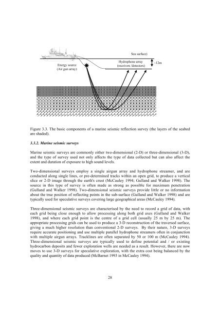
Energy source<br />
(Air gun array)<br />
28<br />
Sea surface)<br />
Hydrophone array<br />
(receivers /detectors)<br />
Figure 3.3. The basic components <strong>of</strong> a marine seismic reflection survey (the layers <strong>of</strong> the seabed<br />
are shaded).<br />
3.3.2. Marine seismic surveys<br />
Marine seismic surveys are commonly either two-dimensional (2-D) or three-dimensional (3-D),<br />
<strong>and</strong> the type <strong>of</strong> survey used not only affects the type <strong>of</strong> data collected but can also affect the<br />
extent <strong>and</strong> duration <strong>of</strong> exposure to high sound levels.<br />
Two-dimensional surveys employ a single airgun array <strong>and</strong> hydrophone streamer, <strong>and</strong> are<br />
conducted along single lines, or pre-determined tracks within an open grid, to produce a vertical<br />
slice or 2-D image through the earth's crust (McCauley 1994; Gull<strong>and</strong> <strong>and</strong> Walker 1998). The<br />
source in this type <strong>of</strong> survey is <strong>of</strong>ten made as strong as possible for maximum penetration<br />
(Gull<strong>and</strong> <strong>and</strong> Walker 1998). Two-dimensional seismic surveys provide little or no information<br />
about the true position <strong>of</strong> reflecting points in the sub-surface (Gull<strong>and</strong> <strong>and</strong> Walker 1998) <strong>and</strong> are<br />
typically used for speculative surveys covering large geographical areas (McCauley 1994).<br />
Three-dimensional seismic surveys are characterised by the need to record a grid <strong>of</strong> data, with<br />
each grid being close enough to allow processing along both grid axes (Gull<strong>and</strong> <strong>and</strong> Walker<br />
1998), <strong>and</strong> where each grid point is the centre <strong>of</strong> a grid cell (usually 25 m by 25 m). The<br />
appropriate processing grids can be used to produce a 3-D reconstruction <strong>of</strong> the traversed surface,<br />
giving a much higher resolution than conventional 2-D surveys. By their nature, 3-D surveys<br />
require accurate positioning <strong>and</strong> use multiple parallel hydrophone streamers <strong>of</strong>ten in conjunction<br />
with multiple airgun arrays. Tracklines are <strong>of</strong>ten separated by 50 or 100 m (McCauley 1994).<br />
Three-dimensional seismic surveys are typically used to define potential <strong>and</strong> / or existing<br />
hydrocarbon deposits <strong>and</strong> fewer exploration wells are needed as a result. However, there are now<br />
moves to use 3-D surveys for speculative exploration, with the extra cost being balanced by the<br />
quality <strong>and</strong> quantity <strong>of</strong> data produced (McBarnet 1993 in McCauley 1994).<br />
~12m