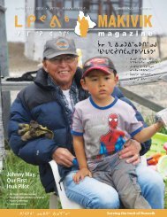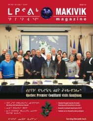
Makivik Magazine Issue 115

You also want an ePaper? Increase the reach of your titles
YUMPU automatically turns print PDFs into web optimized ePapers that Google loves.
2035 ᐊᕐᕌᒍᖓᓄᑦ ᑎᑭᒍᑎᑦᑎᓂ, ᐊᖏᔪᓕᒐᕐᑐᒧᑦ ᐅᑭᐅᕐᑕᑐᒥ<br />
ᐸᕐᓇᓯᒪᐅᑎᒥᓄᑦ, ᑯᐯᒃᑯᑦ ᑲᕙᒪᖓ ᑐᕌᕐᑐᖅ ᓴᓇᓂᒻᒪᕆᓐᓂᒃ ᐱᓇᓱᕝᕕᐅᖁᓇᒋᑦ<br />
ᓴᐳᒻᒥᒍᒫᕐᓂᐊᓱᓂ 50%-ᖏᓐᓂᒃ ᓄᓀᑦ 49° ᑕᕐᕋᖓᑕ ᖁᓛᓂ. ᑕᒪᓐᓇ<br />
ᓄᐃᑦᓯᕗᖅ ᐱᔪᓐᓇᓯᒍᑎᑦᓯᐊᒪᕆᐊᓗᒻᒥᒃ ᐃᓄᐃᑦ ᓇᓗᓀᕐᓯᓂᖓᓂᒃ<br />
ᓄᓀᑦ ᐊᒻᒪᓗ ᐆᒪᔪᖃᐅᑏᑦ ᐱᒻᒪᕆᐅᓂᖏᓐᓂᒃ ᓴᐳᒻᒥᔭᐅᑎᓚᖓᓗᒋᑦ.<br />
ᐊᒥᓱᓕᒐᕐᑐᑦ ᐊᐱᕐᓱᓃᑦ ᑲᔪᓯᑎᑕᐅᒌᓚᐅᔪᔪᑦ ᑲᑎᕕᒃ ᓄᓇᓕᓕᒫᑦ ᑲᕙᒪᖓᓄᑦ<br />
(KRG) ᐊᒻᒪᓗ ᑯᐯᒃᑯᑦ ᑲᕙᒪᖓᓄᑦ (ᐊᕐᖁᑎᖃᕐᑎᓗᒋᑦ ᑐᕐᖃᑕᕐᕕᑯᓐᓂᒃ<br />
ᐊᑯᓂᕆᒍᓐᓇᑐᓂᒃ ᐱᕙᓪᓕᐊᓂᕐᒧᑦ, ᐊᕙᑎᒧᑦ ᐊᒻᒪᓗ ᐊᑭᓂᐊᕐᓂᒧᑦ ᓯᓚᐅᑉ<br />
ᐊᓯᑦᔨᓂᖓᓂᒃ/MDDELCC). ᑭᓯᐊᓂ, ᒪᑭᑎᕆᓚᖓᓗᑕ ᐱᐊᓚᔪᒥᒃ<br />
ᐱᑐᑦᓯᒪᐅᑎᒍᑎᒥᒃ ᓴᐳᒻᒥᔭᐅᓂᓕᓐᓄᑦ ᓄᓇᓄᑦ, ᐱᒋᐊᖃᕐᑐᒍᑦ ᓂᑲᓇᖕᖏᑐᒥᒃ<br />
ᖃᐅᔨᒪᓂᕐᒥᒃ ᑕᒪᒃᑯᐊ ᓯᓚᐅᑉ ᐊᓯᑦᔨᕈᑎᖏᑦᑕ ᓱᒻᒣᒍᑎᒋᓚᖓᔭᖏᓂᒃ<br />
ᑕᒪᒃᑯᓇᓂ ᓂᑲᓇᕐᑐᐊᐱᓐᓂ ᐅᑭᐅᕐᑕᑐᒥ ᐆᒪᔪᖃᐅᑎᓂ. ᑕᒪᓐᓇ ᑎᒍᒥᐊᕐᓱᒍ,<br />
KRG-ᑯᑦ MDDELCC-ᑯᓗ ᐱᖃᑎᒌᒍᑎᖃᕐᓯᒪᔪᒍᑦ ᓴᓇᑦᓱᑕ ᐊᑦᑕᓇᕐᓯᒍᓐᓇᑐᓄᑦ<br />
ᓄᓇᖕᖑᐊᓂᒃ ᐃᑲᔪᕐᓯᒍᑕᐅᑎᓪᓗᒍ ᑖᒃᑯᐊ ᑐᑭᑖᑲᑦᑕᓂᖓᓂᒃ ᐱᑦᔪᑎᖃᓕᕈᑎᒃ<br />
ᓄᖑᑎᕆᑦᑌᓕᓂᕐᒥᒃ ᓄᓇᕕᐅᑉ ᓄᓇᖓᓂ. ᐊᕐᕌᒍᓂ ᐱᖓᓱᓂ ᐊᓂᒍᕐᑐᓂ,<br />
ᓄᐊᑦᓯᓯᒪᔪᒍᑦ ᐊᒥᒐᖕᖏᑐᓂᒃ ᓯᓚᒨᓕᖓᔪᓂᒃ, ᐆᒪᔪᓅᓕᖓᔪᓂᓪᓗ, ᐊᒻᒪᓗ<br />
ᐆᒪᔪᖃᕐᕕᓅᓕᖓᔪᓂᒃ ᖃᐅᔨᒪᒍᑎᓂᒃ ᑕᒐ ᑕᑯᔭᐅᑎᒍᒪᓕᕐᑕᑎᓐᓂᒃ.<br />
By 2035, with its large scale Plan Nord, the Quebec government aims<br />
to protect from industrial activities 50% of the land lying north of the<br />
49 th parallel. This represents a great opportunity for Inuit to pinpoint<br />
important regions and ecosystems to protect. Large-scale interviews<br />
have already been conducted by the Kativik Regional Government<br />
(KRG) and the Quebec government (through the ministère du<br />
Développement Durable, de l’Environnement et de la Lutte contre les<br />
Changements Climatiques/MDDELCC). However, to build an efficient<br />
network of protected areas, we need to acquire sound knowledge of<br />
the impacts of climate change on these fragile Northern ecosystems.<br />
In this context, we have partnered with KRG and MDDELCC to build<br />
climate change vulnerability maps to help their decision-making for<br />
the conservation of Nunavik’s territory. Over the past three years, we<br />
have gathered a large amount of climatic, biological, and ecological<br />
data that we now wish to share.<br />
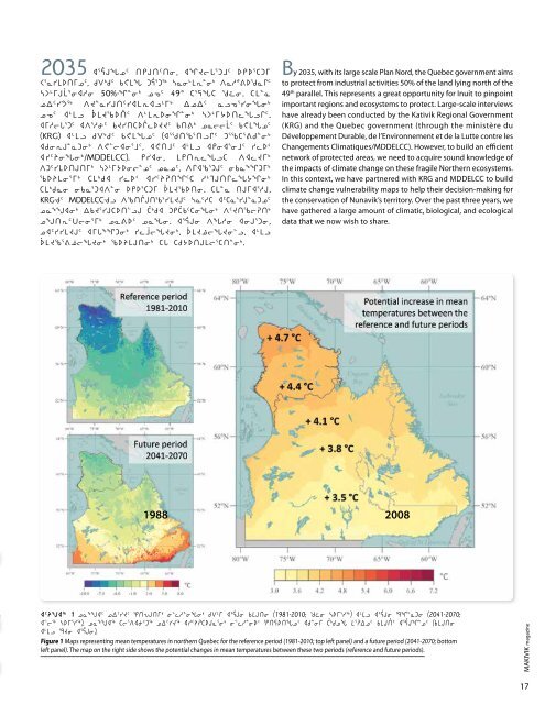
1988 2008<br />
ᐊᑦᔨᖑᐊᖅ 1 ᓄᓇᖕᖑᐊᑦ ᓄᐃᑦᓯᔪᑦ ᕿᑎᕃᒍᑎᒥᒃ ᓂᓪᓚᓱᓐᓂᖓᓂᒃ ᑯᐯᒻᒥ ᐊᕐᕌᒍᓂ ᑲᒪᒍᑎᓂ (1981-2010; ᖁᓛᓂ ᓴᐅᒥᕐᓯᖅ) ᐊᒻᒪᓗ ᐊᕐᕌᒍᓂ ᙯᖏᓐᓇᑐᓂ (2041-2070;<br />
ᐊᓪᓕᖅ ᓴᐅᒥᕐᓯᖅ). ᓄᓇᖕᖑᐊᖅ ᑕᓕᕐᐱᐊᓃᑦᑐᖅ ᓄᐃᑦᓯᔪᖅ ᐊᓯᑦᔨᕈᑕᐅᒍᓇᕐᓂᒃ ᓂᓪᓚᓱᓐᓂᐅᑉ ᕿᑎᕋᐅᑎᖓᓄᑦ ᐊᑯᓐᓂᒥ ᑖᒃᑯᓄᖓ ᒪᕐᕈᐃᓄᑦ ᑲᒪᒍᑏᑦ ᐊᕐᕌᒍᖏᓐᓄᑦ (ᑲᒪᒍᑎᓂ<br />
ᐊᒻᒪᓗ ᙯᔪᓂ ᐊᕐᕌᒍᓂ).<br />
Figure 1 Maps representing mean temperatures in northern Quebec for the reference period (1981-2010; top left panel) and a future period (2041-2070; bottom<br />
left panel). The map on the right side shows the potential changes in mean temperatures between these two periods (reference and future periods).<br />
MAKIVIK mag a zine<br />
17