
Create successful ePaper yourself
Turn your PDF publications into a flip-book with our unique Google optimized e-Paper software.
3<br />
THE QUEEN'S COLLEGE LIBRARY INSIGHT<br />
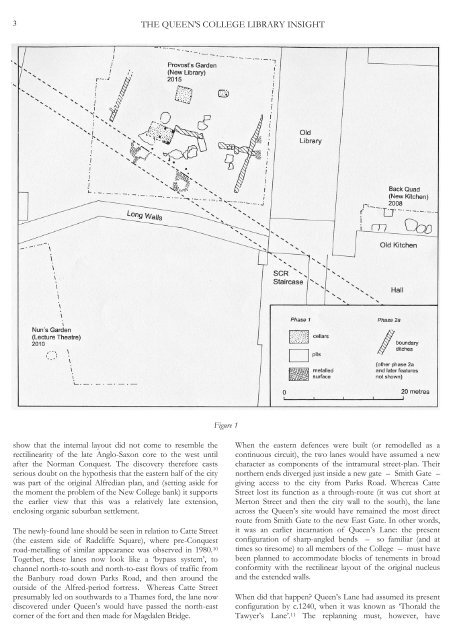
Figure 1<br />
show that the internal layout did not come to resemble the<br />
rectilinearity of the late Anglo-Saxon core to the west until<br />
after the Norman Conquest. The discovery therefore casts<br />
serious doubt on the hypothesis that the eastern half of the city<br />
was part of the original Alfredian plan, and (setting aside for<br />
the moment the problem of the New College bank) it supports<br />
the earlier view that this was a relatively late extension,<br />
enclosing organic suburban settlement.<br />
The newly-found lane should be seen in relation to Catte Street<br />
(the eastern side of Radcliffe Square), where pre-Conquest<br />
road-metalling of similar appearance was observed in 1980. 10<br />
Together, these lanes now look like a ‘bypass system’, to<br />
channel north-to-south and north-to-east flows of traffic from<br />
the Banbury road down Parks Road, and then around the<br />
outside of the Alfred-period fortress. Whereas Catte Street<br />
presumably led on southwards to a Thames ford, the lane now<br />
discovered under Queen’s would have passed the north-east<br />
corner of the fort and then made for Magdalen Bridge.<br />
When the eastern defences were built (or remodelled as a<br />
continuous circuit), the two lanes would have assumed a new<br />
character as components of the intramural street-plan. Their<br />
northern ends diverged just inside a new gate – Smith Gate –<br />
giving access to the city from Parks Road. Whereas Catte<br />
Street lost its function as a through-route (it was cut short at<br />
Merton Street and then the city wall to the south), the lane<br />
across the Queen’s site would have remained the most direct<br />
route from Smith Gate to the new East Gate. In other words,<br />
it was an earlier incarnation of Queen’s Lane: the present<br />
configuration of sharp-angled bends – so familiar (and at<br />
times so tiresome) to all members of the College – must have<br />
been planned to accommodate blocks of tenements in broad<br />
conformity with the rectilinear layout of the original nucleus<br />
and the extended walls.<br />
When did that happen? Queen’s Lane had assumed its present<br />
configuration by c.1240, when it was known as ‘Thorald the<br />
Tawyer’s Lane’. 11 The replanning must, however, have