- Page 1 and 2:
Volume Four Draft Cork County Devel
- Page 3 and 4:
CLICK NAME TO GO DIRECT TO SECTION
- Page 5 and 6:
CHAPTER 1 CARRIGALINE MUNICIPAL DIS
- Page 7 and 8:
CONTENTS Contents 1.1 Overview of C
- Page 9 and 10:
Figure 4.1.1 Map of the Municipal D
- Page 11 and 12:
Private households by occupancy typ
- Page 13 and 14:
Table 4.1.2 Water and Wastewater In
- Page 15 and 16:
Cork Harbour Cluster 1.2.4 The Cork
- Page 17 and 18:
Table 4.1.3 Carrigaline Population,
- Page 19 and 20:
Table 4.1.6: Carrigaline Opportunit
- Page 21 and 22:
Employment and Economic Activity 1.
- Page 23 and 24:
economic survival and development o
- Page 25 and 26:
etween urban areas and the countrys
- Page 27 and 28:
Phase 2 1.3.102 This phase of the d
- Page 29 and 30:
Table 4.1.7: General Objectives for
- Page 31 and 32:
Table 4.1.8: Specific Development O
- Page 33 and 34:
Table 4.1.8: Specific Development O
- Page 35 and 36:
Figure 4.1.4: Map of Carrigaline. 3
- Page 37 and 38:
Cobh - Midleton - Carrigtwohill - L
- Page 39 and 40:
The vision is to see Passage West/G
- Page 41 and 42:
Figure 4.1.5 Passage West/Glenbrook
- Page 43 and 44:
1.4.68 Passage West has a well defi
- Page 45 and 46:
note is that the site supports an i
- Page 47 and 48:
General Objectives 1.4.105 The foll
- Page 49 and 50:
Table 4.1.13: Specific Development
- Page 51 and 52:
Key Villages and Strategic Employme
- Page 53 and 54:
Port of Cork 1.5.23 Cork Harbour is
- Page 55 and 56:
Figure 4.1.7: Ringaskiddy Green Inf
- Page 57 and 58:
1.5.64 2Special Protection Area’s
- Page 59 and 60:
Specific Objectives 1.5.75 The foll
- Page 61 and 62:
Table 4.1.16: Specific Development
- Page 63 and 64:
Table 4.1.16: Specific Development
- Page 65 and 66:
1.6 Crosshaven and Bays Vision and
- Page 67 and 68:
and visual setting of Cork Harbour.
- Page 69 and 70:
ealm around Cronins/ Crosshaven Hou
- Page 71 and 72:
Table 4.1.20: Specific Development
- Page 73 and 74:
Figure 4.1.9: Map of Crosshaven and
- Page 75 and 76:
Figure 4.1.10: Map of Ballinhassig.
- Page 77 and 78:
Figure 4.1.11: Map of Ballygarvan.
- Page 79 and 80:
Figure 4.1.12: Map of Halfway. 79
- Page 81 and 82:
Figure 4.1.13: Map of Minane Bridge
- Page 83 and 84:
Figure 4.1.14: Map of Waterfall. 83
- Page 85 and 86:
CHAPTER 2 COBH MUNICIPAL DISTRICT 8
- Page 87 and 88:
CONTENTS Contents 2.1 Overview of t
- Page 89 and 90:
Figure 4.2.1: Cobh MD 2.2 Cobh Muni
- Page 91 and 92:
Table 4.2.2: Cobh Municipal Distric
- Page 93 and 94:
Local Context 2.3.8 Carrigtwohill i
- Page 95 and 96:
of uses to be accommodated, priorit
- Page 97 and 98:
Social and Community facilities 2.3
- Page 99 and 100:
the site with the town centre and r
- Page 101 and 102:
improvements to pedestrian and cycl
- Page 103 and 104:
2.3.86 The vision for the Carrigtwo
- Page 105 and 106:
Table 4.2.7 Carrigtwohill North Urb
- Page 107 and 108:
Table 4.2.8: Carrigtwohill North Ur
- Page 109 and 110:
Irish Rail, will, subject to agreem
- Page 111 and 112:
Objective No. CT-GO-17 CT-GO-18 CT-
- Page 113 and 114:
County Development Plan Objectives
- Page 115 and 116:
County Development Plan Objectives
- Page 117 and 118:
117
- Page 119 and 120:
2.4.12 A large component of the lan
- Page 121 and 122:
Table 4.2.12: Cobh Regeneration Are
- Page 123 and 124:
2.4.40 Some areas which are zoned f
- Page 125 and 126:
2.4.58 A core principle of this Pla
- Page 127 and 128:
Movement 2.4.64 Cobh’s capacity t
- Page 129 and 130:
Flooding 2.4.87 Flood risk is not a
- Page 131 and 132:
Ballynoe UEA Land Use Proposals Bal
- Page 133 and 134:
Table 4.2.13: Phased Development Pr
- Page 135 and 136:
Objective No. CH-GO-15 CT-GO-16 CH-
- Page 137 and 138:
County Development Plan Objectives
- Page 139 and 140:
139
- Page 141 and 142:
Table 4.2.15: Little Island Populat
- Page 143 and 144:
Town Centre and Retail 2.5.24 While
- Page 145 and 146:
Built Heritage 2.5.41 There are 4 n
- Page 147 and 148:
Objective No. LI-GO-09 LI-GO-10 Gen
- Page 149 and 150: County Development Plan Objectives
- Page 151 and 152: 151
- Page 153 and 154: Overall Scale of Development Popula
- Page 155 and 156: Eireann as the town expands. Howeve
- Page 157 and 158: for any new development in Monard t
- Page 159 and 160: Key Villages 2.7 Carrignavar Vision
- Page 161 and 162: County Development Plan Objective S
- Page 163 and 164: 2.8 Glounthaune Vision and Context
- Page 165 and 166: desirable to see a pedestrian/cycle
- Page 167 and 168: 167
- Page 169 and 170: Special Policy Area X-01 2.9.11 The
- Page 171 and 172: Specific Objectives 2.9.31 The foll
- Page 173 and 174: 2.10 Specialist Employment Centre 2
- Page 175 and 176: County Development Plan Objective D
- Page 177 and 178: Villages 2.12 Knockraha Vision and
- Page 179 and 180: 179
- Page 181 and 182: Specific Objectives 2.13.1 The foll
- Page 183 and 184: 2.14 Other Locations 2.14.1 There a
- Page 185 and 186: uildings of heritage importance inc
- Page 187 and 188: 187
- Page 189 and 190: 189
- Page 191 and 192: CHAPTER 3 EAST CORK MUNICIPAL DISTR
- Page 193 and 194: CONTENTS Contents 3.1 East Cork Mun
- Page 195 and 196: 3.1 East Cork Municipal District Ov
- Page 197 and 198: 3.2 East Cork Municipal District Pr
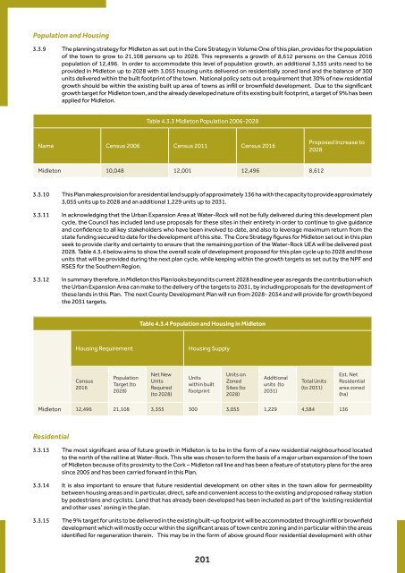
- Page 199: Table 4.3.2 East Cork Municipal Dis
- Page 203 and 204: Special Policy Areas: Midleton Resi
- Page 205 and 206: Regeneration Areas: Midleton Regene
- Page 207 and 208: Regeneration Areas: Midleton Regene
- Page 209 and 210: Social and Community Facilities 3.3
- Page 211 and 212: Figure 4.3.4 - Midleton Green Infra
- Page 213 and 214: 3.3.54 Given the direct and indirec
- Page 215 and 216: and Killeagh. When finished the new
- Page 217 and 218: urban drainage systems (SUDS), silt
- Page 219 and 220: at national, regional and local lev
- Page 221 and 222: Table 4.3.5 Water-Rock Urban Expans
- Page 223 and 224: Water-Rock Social and Community Inf
- Page 225 and 226: County Development Plan Objectives
- Page 227 and 228: County Development Plan Objectives
- Page 229 and 230: County Development Plan Objectives
- Page 231 and 232: County Development Plan Objectives
- Page 233 and 234: County Development Plan Objectives
- Page 235 and 236: County Development Plan Objectives
- Page 237 and 238: County Development Plan Objectives
- Page 239 and 240: County Development Plan Objectives
- Page 241 and 242: 3.4 Youghal Eochaill - Yew Woods Vi
- Page 243 and 244: implemented in the town. Some of th
- Page 245 and 246: Regeneration Areas: Youghal Regener
- Page 247 and 248: Figure 4.3.5 Youghal Green Infrastr
- Page 249 and 250: suitable for all ages and abilities
- Page 251 and 252:
eed swamps within the SAC, with wet
- Page 253 and 254:
County Development Plan Objectives
- Page 255 and 256:
County Development Plan Objectives
- Page 257 and 258:
County Development Plan Objectives
- Page 259 and 260:
County Development Plan Objectives
- Page 261 and 262:
3.5 Key Villages Purpose of this Se
- Page 263 and 264:
e alleviated somewhat by the propos
- Page 265 and 266:
County Development Plan Objectives
- Page 267 and 268:
3.7 Cloyne ‘Cluain Uamha’ - Mea
- Page 269 and 270:
3.7.18 Provision should be made for
- Page 271 and 272:
County Development Plan Objectives
- Page 273 and 274:
3.8 Whitegate and Aghada Whitegate
- Page 275 and 276:
3.8.19 Whitegate and Aghada is desi
- Page 277 and 278:
Specific Zoning Objectives Whitegat
- Page 279 and 280:
County Development Plan Objectives
- Page 281 and 282:
281
- Page 283 and 284:
3.9.13 The development of the 23km
- Page 285 and 286:
Specific Objectives 3.9.28 The foll
- Page 287 and 288:
3.10 Villages Introduction 3.10.1 T
- Page 289 and 290:
289
- Page 291 and 292:
County Development Plan Objective -
- Page 293 and 294:
3.13 Ballymacoda Vision 3.13.1 The
- Page 295 and 296:
3.14 Dungourney Vision Dún Guairne
- Page 297 and 298:
3.15 Ladysbridge Vision 3.15.1 The
- Page 299 and 300:
3.16 Lisgoold Vision 3.16.1 The str
- Page 301 and 302:
3.17 Mogeely Vision 3.17.1 The stra
- Page 303 and 304:
3.18 Saleen Vision 3.18.1 The strat
- Page 305 and 306:
305
- Page 307 and 308:
307
- Page 309 and 310:
County Development Plan Objective -
- Page 311 and 312:
311
- Page 313 and 314:
CHAPTER 4 MACROOM MUNICIPAL DISTRIC
- Page 315 and 316:
CONTENTS Contents 4.1 Macroom Munic
- Page 317 and 318:
4.1 Macroom Municipal District Over
- Page 319 and 320:
4.2 Macroom Municipal District Prof
- Page 321 and 322:
Table 4.2.2: Macroom Municipal Dist
- Page 323 and 324:
Population and Housing 4.3.8 For th
- Page 325 and 326:
Table 4.2.6: Macroom Regeneration A
- Page 327 and 328:
4.3.20 It is a policy of the Plan t
- Page 329 and 330:
Figure 4.2 Green Infrastructure Map
- Page 331 and 332:
some streets leading to the town ce
- Page 333 and 334:
4.3.22 Proposals have been included
- Page 335 and 336:
General Objectives County Developme
- Page 337 and 338:
County Development Plan Objectives:
- Page 339 and 340:
339
- Page 341 and 342:
Placemaking and Public Realm 4.4.7
- Page 343 and 344:
Movement Roads 4.4.27 Millstreet ha
- Page 345 and 346:
County Development Plan Objectives:
- Page 347 and 348:
County Development Plan Objectives:
- Page 349 and 350:
4.5 Key Villages in the Macroom MD
- Page 351 and 352:
Infrastructure 4.6.11 The WWTP in K
- Page 353 and 354:
County Development Plan Objectives:
- Page 355 and 356:
4.7 Béal Átha an Ghaorthaidh Visi
- Page 357 and 358:
4.7.21 The village is located on a
- Page 359 and 360:
4.8 Baile Mhic Íre / Baile Bhuirne
- Page 361 and 362:
4.8.24 Baile Mhic Íre / Baile Bhui
- Page 363 and 364:
363
- Page 365 and 366:
4.9.11 Coachford is served by a sep
- Page 367 and 368:
367
- Page 369 and 370:
4.11 Aghabullogue 4.11.1 The vision
- Page 371 and 372:
4.12 Aherla 4.12.1 The vision for A
- Page 373 and 374:
4.13 Ballynora 4.13.1 The vision fo
- Page 375 and 376:
4.14 Cloghduv 4.14.1 The vision for
- Page 377 and 378:
4.15 Clondrohid 4.15.1 The vision f
- Page 379 and 380:
4.16 Courtbrack 4.16.1 The vision f
- Page 381 and 382:
4.17 Crookstown 4.17.1 The vision f
- Page 383 and 384:
4.18 Inchigeelagh 4.18.1 The vision
- Page 385 and 386:
385
- Page 387 and 388:
387
- Page 389 and 390:
389
- Page 391 and 392:
391
- Page 393 and 394:
393
- Page 395 and 396:
395
- Page 397 and 398:
397
- Page 399 and 400:
4.27 Inniscarra 4.27.1 Inniscarra c