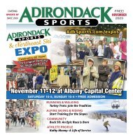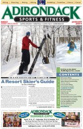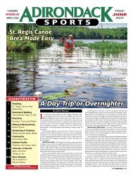
Adirondack Sports September 2023
In this Issue 5 NEWS BRIEFS 7 HIKING: Buck Mountain 11 BICYCLING: Upstate Mountain Bike Boom 15 RUNNING & WALKING: Mosaic of Autumn Possibilities 19 KAYAK, CANOE, SUP: Favorite Paddling Places 23 NON-MEDICATED LIFE: Benefits of Sulforaphane 24 ATHLETE PROFILE: Run & Tri with Judy Guzzo 27-33 CALENDAR OF EVENTS: Bounty of Fall Things to Do 35 SWIMMING: Back to the Pool with Masters 39-47 RACE RESULTS: Top Summer Finishers
In this Issue
5 NEWS BRIEFS
7 HIKING: Buck Mountain
11 BICYCLING: Upstate Mountain Bike Boom
15 RUNNING & WALKING: Mosaic of Autumn Possibilities
19 KAYAK, CANOE, SUP: Favorite Paddling Places
23 NON-MEDICATED LIFE: Benefits of Sulforaphane
24 ATHLETE PROFILE: Run & Tri with Judy Guzzo
27-33 CALENDAR OF EVENTS: Bounty of Fall Things to Do
35 SWIMMING: Back to the Pool with Masters
39-47 RACE RESULTS: Top Summer Finishers

Create successful ePaper yourself
Turn your PDF publications into a flip-book with our unique Google optimized e-Paper software.
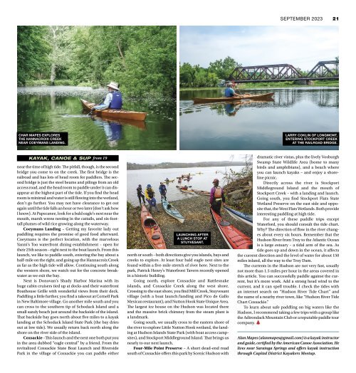
SEPTEMBER <strong>2023</strong> 21<br />
CHAR MAPES EXPLORES<br />
THE HANNACROIX CREEK<br />
NEAR COEYMANS LANDING.<br />
LARRY COKLIN OF LONGMONT,<br />
ENTERING STOCKPORT CREEK<br />
AT THE RAILROAD BRIDGE.<br />
KAYAK, CANOE & SUP from 19<br />
near the time of high tide. The pitfall, though, is the second<br />
bridge you come to on the creek. The first bridge is the<br />
railroad and has lots of head room for paddlers. The second<br />
bridge is just the steel beams and pilings from an old<br />
access road, and the head room to paddle under it can disappear<br />
at the highest part of the tide. If you find the head<br />
room is minimal and water is still flowing into the wetland,<br />
don’t go further. You may not have clearance to get out<br />
again until the tide falls an hour or two later (don’t ask how<br />
I know). At Papscanee, look for a bald eagle’s nest near the<br />
mouth, marsh wrens nesting in the cattails, and six-foottall<br />
plumes of wild rice growing along the waterway.<br />
Coeymans Landing – Getting my favorite lady out<br />
paddling requires the promise of good food afterward.<br />
Coeymans is the perfect location, with the marvelous<br />
Yanni’s Too waterfront dining establishment – open for<br />
their 25th season – right next to the boat launch. From this<br />
launch, we like to paddle south, entering the bay about a<br />
half-mile on the right, and going up the Hannacroix Creek<br />
as far as the high tide will allow. Continuing south along<br />
the western shore, we watch out for the concrete breakwater<br />
as we exit the bay.<br />
Next is Donovan’s Shady Harbor Marina with its<br />
huge cabin cruisers tied up at docks and their waterfront<br />
Boathouse Grille with wonderful views from their deck.<br />
Paddling a little further, you find a takeout at Cornell Park<br />
in New Baltimore village. Go another mile south and you<br />
can cross to the southern tip of Schodack Island and a<br />
small sandy beach just around the backside of the island.<br />
That backside bay goes north about five miles to a kayak<br />
landing at the Schodack Island State Park (the bay dries<br />
out at low tide). We usually return back north along the<br />
shore on the river side of the island.<br />
Coxsackie –This launch and the next one both put you<br />
in the area dubbed “eagle central” by a friend. From the<br />
revitalized Coxsackie State Boat Launch and Riverside<br />
Park in the village of Coxsackie you can paddle either<br />
LAUNCHING AFTER<br />
A LUNCH STOP AT<br />
STUYVESANT.<br />
north or south – both directions give you islands, bays and<br />
creeks to explore. At least four bald eagle nest sites are<br />
found within a five-mile stretch of river here. Next to the<br />
park, Patrick Henry’s Waterfront Tavern recently opened<br />
in a historic building.<br />
Going north, explore Coxsackie and Rattlesnake<br />
islands, and Coxsackie Creek along the west shore.<br />
Crossing to the east shore, you find Mill Creek, Stuyvesant<br />
village (with a boat launch/landing and Pico de Gallo<br />
Mexican restaurant), and Nutton Hook State Unique Area.<br />
The largest ice house on the Hudson was located there<br />
and the massive brick chimney from the steam plant is<br />
a landmark.<br />
Going south, we usually cross to the eastern shore of<br />
the river to explore Little Nutton Hook wetland, the landing<br />
at Hudson Islands State Park (with boat access campsites),<br />
and Stockport Middleground Island. That brings us<br />
nearly to our next launch.<br />
Four-Mile Point Preserve – A short dead-end road<br />
south of Coxsackie offers this park by Scenic Hudson with<br />
dramatic river vistas, plus the lively Vosburgh<br />
Swamp State Wildlife Area (home to many<br />
birds and amphibians), and a beach where<br />
you can launch kayaks – and enjoy a shoreline<br />
picnic.<br />
Directly across the river is Stockport<br />
Middleground Island and the mouth of<br />
Stockport Creek – with a landing and launch.<br />
Going south, you find Stockport Flats State<br />
Wetland Preserve on the east side and opposite<br />
that, the West Flats Wetlands. Both provide<br />
interesting paddling at high tide.<br />
For any of these paddle trips except<br />
Waterford, you should consult the tide chart.<br />
Why? The direction of flow in the river changes<br />
about every six hours. Remember that the<br />
Hudson River from Troy to the Atlantic Ocean<br />
is a large estuary – a tidal arm of the sea. As<br />
tide goes up and down in the ocean, it affects<br />
the current direction and the level of water for about 150<br />
miles inland, all the way to the Troy Dam.<br />
The currents in the Hudson are not very fast, usually<br />
not more than 1.5 miles per hour in the areas covered in<br />
this article. You can successfully paddle against the current,<br />
but it’s more work. Add a strong head wind to the<br />
current, and it can spell trouble. I check the tides with<br />
an internet search on “Hudson River Tide Chart” and<br />
the name of a nearby river town, like “Hudson River Tide<br />
Chart Coxsackie.”<br />
To learn about safe paddling on big waters like the<br />
Hudson, I recommend taking a few trips with a group like<br />
the <strong>Adirondack</strong> Mountain Club or a reputable paddle tour<br />
company.<br />
Alan Mapes (alanmapes@gmail.com) is a kayak instructor<br />
and guide, certified by the American Canoe Association. He<br />
lives near Saratoga Springs and offers kayak instruction<br />
through Capital District Kayakers Meetup.