TECHNOLOGY DIGEST - Draper Laboratory
TECHNOLOGY DIGEST - Draper Laboratory
TECHNOLOGY DIGEST - Draper Laboratory

You also want an ePaper? Increase the reach of your titles
YUMPU automatically turns print PDFs into web optimized ePapers that Google loves.
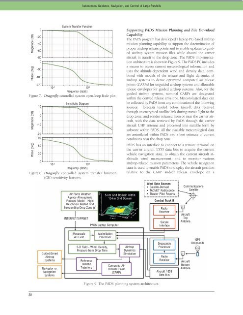
Magnitude (dB)<br />
Phase (deg)<br />
-270<br />
10<br />
Frequency (rad/s)<br />
Figure 7. Dragonfly controlled system open-loop Bode plot.<br />
-1 100 Magnitude (dB)<br />
Phase (deg)<br />
0<br />
10<br />
Frequency (rad/s)<br />
Figure 8. Dragonfly controlled system transfer function<br />
(GK) sensitivity features.<br />
-1 100 20<br />
0<br />
-20<br />
-40<br />
-60<br />
-80<br />
0<br />
-90<br />
-180<br />
10<br />
0<br />
-10<br />
-20<br />
90<br />
60<br />
30<br />
Guided/Smart<br />
Airdrop<br />
Systems<br />
Navigator or<br />
Navigation<br />
Systems<br />
System Transfer Function<br />
Sensitivity Diagram<br />
Air Force Weather<br />
Agency Atmospheric<br />
Forecast Model - High:<br />
Resolution Nested Grid<br />
Surrounding Drop Zone (s)<br />
INTERNET/SIPRNET<br />
Mesoscale<br />
4D Field<br />
Autonomous Guidance, Navigation, and Control of Large Parafoils<br />
PADS Laptop Computer<br />
3-D Field - Wind, Density,<br />
Pressure from Drop Time<br />
Reference<br />
Ballistic<br />
Trajectory<br />
5-km Grid Domain within<br />
15-km Grid Domain<br />
Assimilation<br />
Processor<br />
Computed Air<br />
Release Point<br />
(CARP)<br />
Supporting PADS Mission Planning and File Download<br />
Capability<br />
The PADS program has developed a laptop PC-based airdrop<br />
mission planning capability to support the determination of<br />
proper airdrop release points and to enable updates to guided<br />
airdrop system mission files while aboard the carrier<br />
aircraft in transit to the drop zone. The PADS implementation<br />
architecture is shown in Figure 9. The PADS PC includes<br />
a means to access current meteorological information and<br />
uses the altitude-dependent wind and density data, combined<br />
with models of the release and flight dynamics of<br />
airdrop systems to derive optimized computed air release<br />
points (CARPs) for unguided airdrop systems and allowable<br />
release envelopes for guided airdrop systems. Also, for the<br />
guided airdrop systems, nominal CARPs are designated<br />
within the derived release envelope. Meteorological data can<br />
be collected by PADS from any combination of the following<br />
sources: forecasts loaded before takeoff; data received<br />
through an encrypted satellite link during transit flight to the<br />
drop zone; and sondes released from or near the carrier aircraft,<br />
with the data retrieved by PADS through the carrier<br />
aircraft UHF antenna and processed into suitable form by<br />
software within PADS. All the available meteorological data<br />
are assimilated within PADS into a best estimate of current<br />
conditions near the drop zone.<br />
PADS has an interface to connect to a remote terminal on<br />
the carrier aircraft 1553 data bus to acquire the current<br />
vehicle navigation state, to obtain the current aircraft ataltitude<br />
wind measurement, and to monitor various<br />
airdrop-related mission parameters. The vehicle navigation<br />
state is used to enable PADS to display the aircraft position<br />
relative to the CARP and/or release envelope on a<br />
Airdrop<br />
Dynamics<br />
Simulation<br />
Figure 9. The PADS planning system architecture.<br />
Wind Data Sources<br />
• Satellite-Derived<br />
• TACMET Radiosonde<br />
• Theater Pilot Reports<br />
Combat Track II<br />
Radio<br />
Receiver<br />
Secure<br />
Interface<br />
Dropsonde<br />
Processor<br />
Radio<br />
Receiver<br />
Aircraft 1553<br />
Data Bus<br />
Communications<br />
Satellite<br />
Aircraft<br />
Top<br />
Antenna<br />
Aircraft<br />
Bottom<br />
Antenna<br />
GPS<br />
Dropsonde