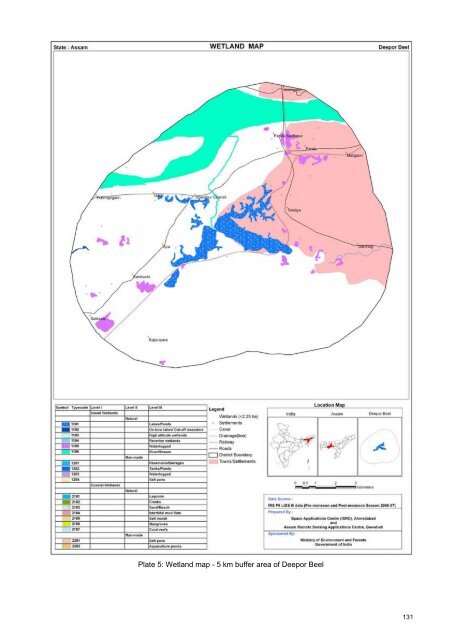
9.1 Deepor Beel Name Deepor Beel 26° 07' 30" N, 91° 38' 35" E Location District: Kamrup Ownership: State, Fishery Department Area 589 ha Altitude 53 m Wetl<strong>and</strong> Type Freshwater Swamp, Lake Rainfall : >2000 mm Climate Temperature: 7 °C to 37 °C Status Wildlife Sanctuary, established in January 1989. Presently it is a Ramsar Site (designated in November 2002). This is a fresh water lake, on the southern bank <strong>of</strong> the Brahmaputra River, covering an area <strong>of</strong> about 900 ha. The main source <strong>of</strong> water <strong>of</strong> this lake is from rainfall run<strong>of</strong>f <strong>and</strong> from the Basistha <strong>and</strong> Description Kalamoni rivers. The Beel drains into the Brahmaputra River, located about 5 km away through a small rivulet called Khanajan. The southern side <strong>of</strong> the lake is contiguous with Rani Reserve Forest. About half <strong>of</strong> the Beel dries out during the winter <strong>and</strong> the exposed shores are converted into paddy fields. At maximum flooding, it is c. 4 m deep, while during the dry season, the depth drops to about 1.0 m.. A large variety <strong>of</strong> aquatic flora <strong>of</strong> tropical <strong>wetl<strong>and</strong></strong> is found in Deepor Beel <strong>and</strong> its adjoining areas. The dominant aquatic plants include Azolla pinnata, Nymphaea rubra, Ottelia alismoides, Eleocharis plantaginea, Pistia stratiotes ,Hydrilla verticillata, Potamogeton crispus, Ipomoea reptans, Sagittaria sagittifolia, Nymphaea albea, Vallisneria spiralis. The giant water lily (Euryale ferox) also grows here. Eichhornia crassipes is the dominate weed. Bio-diversity The diversity <strong>and</strong> concentration <strong>of</strong> indigenous fresh water fish species in this lake is very high (around50 species under 19 families). It harbors many species <strong>of</strong> migratory birds in winter as well as resident birds. Around 150 species <strong>of</strong> birds have been recorded so far in <strong>and</strong> around the Sanctuary, including nine threatened species. The <strong>wetl<strong>and</strong></strong> is used for fishery, domestic water supply, collection <strong>of</strong> natural products, fodder <strong>and</strong> food supply, transport, <strong>and</strong> recreation. Current status: Heavy siltation, pollution from city/industry effluents, poaching <strong>and</strong> unregulated Current Status fishing, encroachment. As observed in the image, the beel is fragmented, surrounded with waterlogged areas in the 5 km buffer zone. The intensive growth <strong>of</strong> the weed water hyacinth is very prominent. The field photograph shows the shallowness <strong>of</strong> water, growth <strong>of</strong> vegetation in <strong>and</strong> around the lake. IRS LISS-III Post monsoon data (November 1, 2006) IRS LISS-III Pre-monsoon data (May 27, 2007) Plate 4: Deepor Beel 130
Plate 5: Wetl<strong>and</strong> map - 5 km buffer area <strong>of</strong> Deepor Beel 131