

national wetland atlas assam - Ministry of Environment and Forests
national wetland atlas assam - Ministry of Environment and Forests
national wetland atlas assam - Ministry of Environment and Forests

You also want an ePaper? Increase the reach of your titles
YUMPU automatically turns print PDFs into web optimized ePapers that Google loves.
7.1.5 Barpeta<br />
The district is situated in the lower Brahmaputra valley <strong>of</strong> Assam between 26°5'N <strong>and</strong> 26°51 'N latitudes <strong>and</strong><br />
90 o 38'E <strong>and</strong> 91°20'E longitudes. It occupies 320704 hectares <strong>of</strong> area. It is bounded by Nalbari District on the<br />
east <strong>and</strong> its north boundary is marked by the kingdom <strong>of</strong> Bhutan.The district is characterised by almost plain<br />
topography with the highest elevation <strong>of</strong> 200 m above m.s.l. in north, while in the south it is below 18 m above<br />
m.s.l. The rivers flowing through the district are Tihu, Kaldia, Pahumara, Palla, Beki <strong>and</strong> Bhalukadoba which<br />
originate from Bhutan hills <strong>and</strong> are perennial in nature. The southern side <strong>of</strong> the district is very low lying <strong>and</strong> is<br />
frequently subjected to flood. Besides these, there are a number <strong>of</strong> small streams, ab<strong>and</strong>oned channels <strong>and</strong><br />
marshy l<strong>and</strong>s. The major soil groups are Recent Riverine Alluvial Soil (Entisols), Old Riverine Alluvial soils<br />
(Inceptisols) <strong>and</strong> Old Mountain Valley Alluvial soils (Alfisols). The general pH value <strong>of</strong> the soils <strong>of</strong> the district<br />
varies from 4.5 to 7.3 i.e. acidic to neutral. The area receives an average rainfall <strong>of</strong> 1409 mm. The maximum<br />
<strong>and</strong> minimum temperatures recorded for the district are 35°C <strong>and</strong> 7°C respectively. As per Census Report,<br />
2001, the district has a total population <strong>of</strong> 16, 47,201.<br />
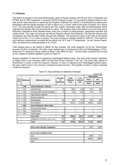
Total <strong>wetl<strong>and</strong></strong> area in the district is 59038 ha that includes 195 small <strong>wetl<strong>and</strong></strong>s (


