

national wetland atlas assam - Ministry of Environment and Forests
national wetland atlas assam - Ministry of Environment and Forests
national wetland atlas assam - Ministry of Environment and Forests

You also want an ePaper? Increase the reach of your titles
YUMPU automatically turns print PDFs into web optimized ePapers that Google loves.
7.1.12 Lakhimpur<br />
The district is situated in the north eastern part <strong>of</strong> Assam between 26o 45'N <strong>and</strong> 27 o 35'N latitudes <strong>and</strong> 93 o 40'E<br />
<strong>and</strong> 94 o 53'E longitudes. It occupies 3, 00,800 hectares <strong>of</strong> area. It is bounded on the east by Dhemaji <strong>and</strong><br />
Dibrugarh districts, on the west by Sonitpur district <strong>and</strong> part <strong>of</strong> Arunachal Pradesh, on the north by Arunachal<br />
Pradesh <strong>and</strong> Dhemaji district. The topography <strong>of</strong> the district varies from undulating upl<strong>and</strong>s on the northern<br />
foothill belt to low lying plains on the south with elevation range <strong>of</strong> 35 metres (areas in riverine belt) to 140<br />
metres (areas in the foothill belt) above the m. s.l. The mean altitude <strong>of</strong> the district is 102 metres above m.s.l. All<br />
the rivers in the district are perennial in nature. The river Brahmaputra flows on the southern side <strong>of</strong> the district.<br />
The other major rivers are Subansiri, Simen <strong>and</strong> Dikrai. The soils <strong>of</strong> the district are broadly fall into three major<br />
groups i.e. Older Alluvium along the foothill Older Alluvium on the flood plains <strong>and</strong> Newer Alluvium on the recent<br />
flood plains. The annual mean rainfall in the district is 300 cm. The maximum <strong>and</strong> minimum temperatures are<br />
31 o C <strong>and</strong> 7 o C respectively, while the mean temperature is 19 o C. As per Census Report, 2001, the district has a<br />
total population <strong>of</strong> 8, 89,010.<br />
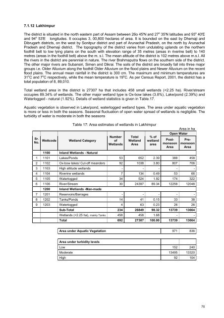
Total <strong>wetl<strong>and</strong></strong> area in the district is 27307 ha that includes 458 small <strong>wetl<strong>and</strong></strong>s (


