

national wetland atlas assam - Ministry of Environment and Forests
national wetland atlas assam - Ministry of Environment and Forests
national wetland atlas assam - Ministry of Environment and Forests

Create successful ePaper yourself
Turn your PDF publications into a flip-book with our unique Google optimized e-Paper software.
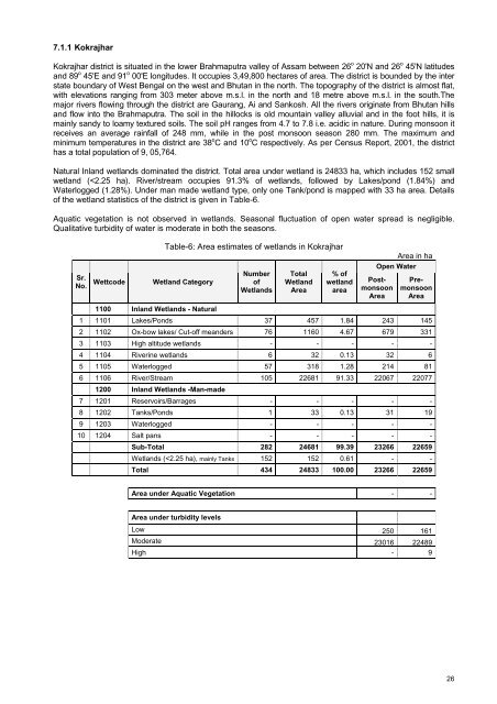
7.1.1 Kokrajhar<br />
Kokrajhar district is situated in the lower Brahmaputra valley <strong>of</strong> Assam between 26 o 20'N <strong>and</strong> 26 o 45'N latitudes<br />
<strong>and</strong> 89 o 45'E <strong>and</strong> 91 o 00'E longitudes. It occupies 3,49,800 hectares <strong>of</strong> area. The district is bounded by the inter<br />
state boundary <strong>of</strong> West Bengal on the west <strong>and</strong> Bhutan in the north. The topography <strong>of</strong> the district is almost flat,<br />
with elevations ranging from 303 meter above m.s.l. in the north <strong>and</strong> 18 metre above m.s.l. in the south.The<br />
major rivers flowing through the district are Gaurang, Ai <strong>and</strong> Sankosh. All the rivers originate from Bhutan hills<br />
<strong>and</strong> flow into the Brahmaputra. The soil in the hillocks is old mountain valley alluvial <strong>and</strong> in the foot hills, it is<br />
mainly s<strong>and</strong>y to loamy textured soils. The soil pH ranges from 4.7 to 7.8 i.e. acidic in nature. During monsoon it<br />
receives an average rainfall <strong>of</strong> 248 mm, while in the post monsoon season 280 mm. The maximum <strong>and</strong><br />
minimum temperatures in the district are 38 o C <strong>and</strong> 10 o C respectively. As per Census Report, 2001, the district<br />
has a total population <strong>of</strong> 9, 05,764.<br />
Natural Inl<strong>and</strong> <strong>wetl<strong>and</strong></strong>s dominated the district. Total area under <strong>wetl<strong>and</strong></strong> is 24833 ha, which includes 152 small<br />
<strong>wetl<strong>and</strong></strong> (


