

national wetland atlas assam - Ministry of Environment and Forests
national wetland atlas assam - Ministry of Environment and Forests
national wetland atlas assam - Ministry of Environment and Forests

You also want an ePaper? Increase the reach of your titles
YUMPU automatically turns print PDFs into web optimized ePapers that Google loves.
7.1.15 Dibrugarh<br />
The district is situated in the north eastern part <strong>of</strong> Assam between 27 o 10'N <strong>and</strong> 27 o 45'N latitudes <strong>and</strong> 94 o 30'E<br />
<strong>and</strong> 95 o 30'E longitudes. It occupies 3,54,500 hectares <strong>of</strong> area, which accounts for 4.52 per cent area <strong>of</strong> the<br />
state. It is bounded on the east by Tinsukia, on the west by part <strong>of</strong> Sibsagar <strong>and</strong> Lakhimpur districts, on the<br />
north by Lakhimpur district <strong>and</strong> south by the Sibsagar district <strong>and</strong> part <strong>of</strong> Arunachal Pradesh. The district is<br />
characterised by a flat monotonous terrain from the Brahmaputra river southwards upto the upper Dihing R.F.<br />
where it starts rising slowly into the broken hills that comprise the foothills <strong>of</strong> the Tirap district <strong>of</strong> Arunachal<br />
Pradesh. The tract is drained by the Brahmaputra river <strong>and</strong> its main tributary the Burhi Dihing <strong>and</strong> the Mai Jan<br />
river. Soils <strong>of</strong> this district are divided into three distinct categories. viz. new alluvial soils in an area extending few<br />
kms to the south <strong>of</strong> the Brahmaputra river, old alluvial soils in the central part <strong>of</strong> the district <strong>and</strong> old mountain<br />
valley alluvial soil located on the foothills <strong>of</strong> Arunachal Pradesh on the district. The average annual rainfall<br />
ranges from a minimum <strong>of</strong> 2134mm to a maximum <strong>of</strong> 3785mm. The minimum <strong>and</strong> maximum temperatures<br />
recorded are 7 o C <strong>and</strong> 37 o C respectively. As per Census Report, 2001, the district has a total population <strong>of</strong> 11,<br />
85,072.<br />
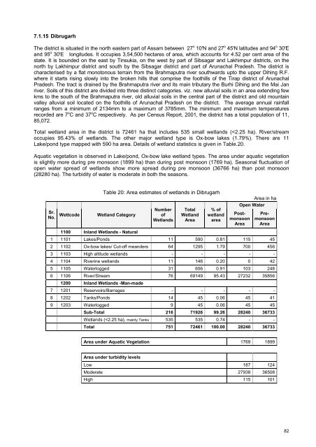
Total <strong>wetl<strong>and</strong></strong> area in the district is 72461 ha that includes 535 small <strong>wetl<strong>and</strong></strong>s (


