

national wetland atlas assam - Ministry of Environment and Forests
national wetland atlas assam - Ministry of Environment and Forests
national wetland atlas assam - Ministry of Environment and Forests

Create successful ePaper yourself
Turn your PDF publications into a flip-book with our unique Google optimized e-Paper software.
7.1.10 Nagaon<br />
The district is situated in the Central Brahmaputra valley <strong>of</strong> Assam between 25 o 35'N <strong>and</strong> 26 o 55'N latitudes <strong>and</strong><br />
92 o 15'E <strong>and</strong> 93 o 20'E longitudes. It occupies 397600 hectares <strong>of</strong> area. It is bounded on the east by Golaghat <strong>and</strong><br />
Karbi Anglong districts, on the west by Marigoan district, on the north by Sonitpur district <strong>and</strong> south by N.C. Hills<br />
<strong>and</strong> Karbi Anglong district. The topography <strong>of</strong> the district is almost flat. The Brahmaputra River flows along the<br />
northern side <strong>of</strong> the district. A number <strong>of</strong> `Char' area [s<strong>and</strong> bars] are observed along the Brahmaputra river bed.<br />
Kaziranga, Loakhowa wild life sanctuary exists in the valley close to the river Brahmaputra. The other major<br />
rivers are Kapili, Diju, Misa, Haria, Jamuna, Kalang <strong>and</strong> Barapani. A number <strong>of</strong> ox-bow lakes <strong>and</strong> ponds also<br />
exist in the district. Besides, there are many low lying areas <strong>and</strong> swamps. The soils <strong>of</strong> the district vary from<br />
s<strong>and</strong>y to clay loam. <strong>and</strong> generally acidic to near neutral in nature. The normal average rainfall in the district is<br />
2000 mm. The average minimum <strong>and</strong> maximum temperatures is 8 o C in January <strong>and</strong> about 34.3 o C in<br />
July/August. As per Census Report, 2001, the district has a total population <strong>of</strong> 23, 14,629<br />
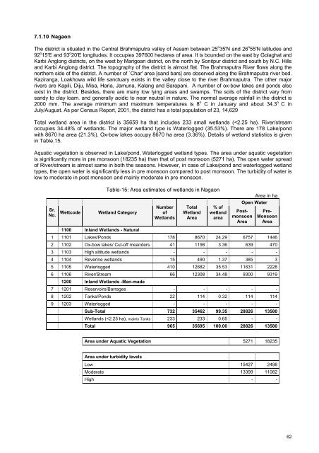
Total <strong>wetl<strong>and</strong></strong> area in the district is 35659 ha that includes 233 small <strong>wetl<strong>and</strong></strong>s (


