

national wetland atlas assam - Ministry of Environment and Forests
national wetland atlas assam - Ministry of Environment and Forests
national wetland atlas assam - Ministry of Environment and Forests

You also want an ePaper? Increase the reach of your titles
YUMPU automatically turns print PDFs into web optimized ePapers that Google loves.
7.1.8 Darrang<br />
The district is situated in the northern part <strong>of</strong> Assam State between 26°10'N <strong>and</strong> 26°58'N Latitudes <strong>and</strong><br />
91°43'E <strong>and</strong> 92°22'E longitudes. It occupies 341399 hectares <strong>of</strong> area. It is bounded on the east by Sonitpur<br />
district, on the north by Bhutan <strong>and</strong> Arunachal Pradesh <strong>and</strong> on the south by the river Brahmaputra. The<br />
topography <strong>of</strong> the district is almost flat Swampy areas <strong>and</strong> naturally depressed vast <strong>wetl<strong>and</strong></strong>s locally known as<br />
beels constitute a sizeable area. The major rivers that traverse through the district are Barnoi, Nanai, Noa-nai,<br />
Mangaldai nai, Mora Dhansiri <strong>and</strong> Dhansiri. The rivers are all perennial in nature. Both new Alluvium Soils<br />
(Entisols) <strong>and</strong> old Alluvium soils (Inceptisols) are found in the district. The average annual rainfall recorded is<br />
1477.72 mm. The maximum temperature recorded is 35.6 o C in the month <strong>of</strong> July-August <strong>and</strong> the minimum is<br />
6 o C in the months <strong>of</strong> December - January. As per Census Report, 2001, the district has a total population <strong>of</strong> 15,<br />
04,320<br />
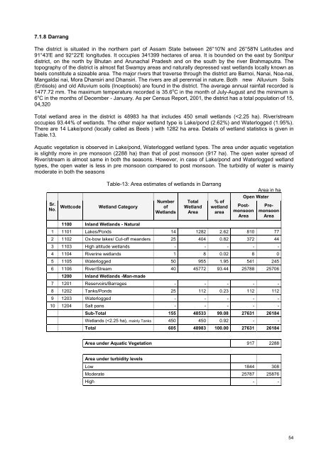
Total <strong>wetl<strong>and</strong></strong> area in the district is 48983 ha that includes 450 small <strong>wetl<strong>and</strong></strong>s (


