Water Cycle Study - East Devon District Council
Water Cycle Study - East Devon District Council
Water Cycle Study - East Devon District Council

You also want an ePaper? Increase the reach of your titles
YUMPU automatically turns print PDFs into web optimized ePapers that Google loves.
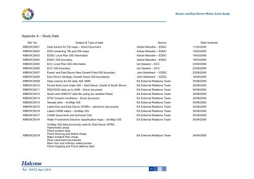
Appendix A – <strong>Study</strong> Data<br />
Ref EWCS April 2010<br />
10<br />
Exeter and <strong>East</strong> <strong>Devon</strong> <strong>Water</strong> <strong>Cycle</strong> <strong>Study</strong><br />
Ref. No Subject & Type of data Source Date received<br />
WBEWCS001 Data licence for OS maps – Word Document Adrian Marsden – EDDC 11/03/2009<br />
WBEWCS002 DVD containing 10k and 50k maps Adrian Marsden – EDDC 19/03/2009<br />
WBEWCS003 EDDC Local Plan GIS information Adrian Marsden – EDDC 19/03/2009<br />
WBEWCS004 EDDC GIS boundary Adrian Marsden – EDDC 19/03/2009<br />
WBEWCS005 ECC Local Plan GIS information Ian Dawson – ECC 23/06/2009<br />
WBEWCS006 ECC GIS boundary Ian Dawson – ECC 23/06/2009<br />
WBEWCS007 Exeter and <strong>East</strong> <strong>Devon</strong> New Growth Point GIS boundary John Maidment – EDDC 23/06/2009<br />
WBEWCS008 <strong>East</strong> <strong>Devon</strong> Strategic Growth Areas GIS boundaries John Maidment – EDDC 18/06/2009<br />
WBEWCS009 Data Licence for EA data, Ref: 8983 EA External Relations Team 30/06/2009<br />
WBEWCS010 Fluvial flood zone maps GIS – <strong>East</strong> <strong>Devon</strong>, Exeter & South <strong>Devon</strong> EA External Relations Team 30/06/2009<br />
WBEWCS011 RQO/GQO data up to 2006 – Excel document EA External Relations Team 30/06/2009<br />
WBEWCS012 South west SIMCAT data file (using dry weather flows) EA External Relations Team 30/06/2009<br />
WBEWCS013 STW Consent conditions – Excel document EA External Relations Team 30/06/2009<br />
WBEWCS014 Sample sites – ArcMap GIS EA External Relations Team 30/06/2009<br />
WBEWCS015 Latest Exe and <strong>East</strong> <strong>Devon</strong> CFMPs – electronic documents EA External Relations Team 30/06/2009<br />
WBEWCS016 Latest CAMS status – ArcMap GIS EA External Relations Team 30/06/2009<br />
WBEWCS017 CAMS documents and technical CDs EA External Relations Team 30/06/2009<br />
WBEWCS018 <strong>Water</strong> Framework Directive classification maps – ArcMap GIS EA External Relations Team 30/06/2009<br />
WBEWCS019<br />
ArcMap GIS data previously used for <strong>East</strong> <strong>Devon</strong> SFRA:<br />
Hydrometric areas<br />
Flood incident data<br />
Flood Warning and Watch Areas<br />
Major Incident Plan Areas<br />
River catchment boundaries<br />
Main river and ordinary watercourses<br />
Flood mapping and Flood defence data<br />
EA External Relations Team 24/04/2008