Water Cycle Study - East Devon District Council
Water Cycle Study - East Devon District Council
Water Cycle Study - East Devon District Council

Create successful ePaper yourself
Turn your PDF publications into a flip-book with our unique Google optimized e-Paper software.
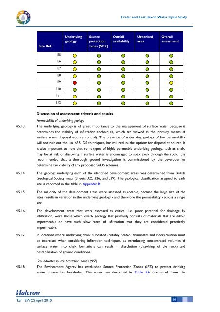
Site Ref.<br />
Ref EWCS April 2010<br />
E5<br />
E6<br />
E7<br />
E8<br />
E9<br />
E10<br />
E11<br />
E12<br />
Underlying<br />
geology<br />
Source<br />
protection<br />
zones (SPZ)<br />
Discussion of assessment criteria and results<br />
Exeter and <strong>East</strong> <strong>Devon</strong> <strong>Water</strong> <strong>Cycle</strong> <strong>Study</strong><br />
Outfall<br />
availability<br />
Urbanised<br />
area<br />
Overall<br />
assessment<br />
Permeablility of underlying geology<br />
4.5.13 The underlying geology is of great importance to the management of surface water because it<br />
determines the viability of infiltration techniques, which are viewed as the primary means of<br />
surface water disposal (source control). The presence of underlying geology of low permeability<br />
will not rule out the use of SuDS techniques, but will reduce the options for disposal at source. It<br />
is also important to note that some types of highly permeable underlying geology, such as chalk,<br />
may be at risk of dissolving if surface water is encouraged to soak away through the rock. It is<br />
recommended that a thorough ground investigation is commissioned by the developer to<br />
determine the viability of any proposed SuDS schemes.<br />
4.5.14 The geology underlying each of the identified development areas was determined from British<br />
Geological Society maps (Sheets 325, 326, and 339). The geological classification assigned to each<br />
site is recorded in the table in Appendix B.<br />
4.5.15 The majority of the development areas were assessed as notable, because the large size of the<br />
sites results in variation in the underlying geology - and therefore the permeability - across a single<br />
site.<br />
4.5.16 The development areas that were assessed as critical (i.e. poor potential for drainage by<br />
infiltration) were those which overly geology that primarily consists of materials that are either<br />
impermeable or have such slow rates of infiltration that they are considered practically<br />
impermeable.<br />
4.5.17 In locations where underlying chalk is located (notably Seaton, Axminster and Beer) caution must<br />
be exercised when considering infiltration techniques, as introducing concentrated volumes of<br />
surface water into chalk formations can result in dissolution (dissolving of the rock) and<br />
destabilisation of ground conditions.<br />
Groundwater source protection zones (SPZ)<br />
4.5.18 The Environment Agency has established Source Protection Zones (SPZ) to protect drinking<br />
water abstraction boreholes. The zones are described in Table 4.6 (extracted from the<br />
36