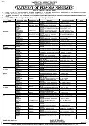
Water Cycle Study - East Devon District Council
Water Cycle Study - East Devon District Council
Water Cycle Study - East Devon District Council

You also want an ePaper? Increase the reach of your titles
YUMPU automatically turns print PDFs into web optimized ePapers that Google loves.
Exeter and <strong>East</strong> <strong>Devon</strong> <strong>Water</strong> <strong>Cycle</strong> <strong>Study</strong><br />
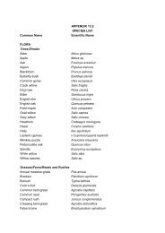
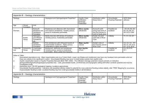
Appendix B – Geology characteristics<br />
Geology Geological and Hydrogeological Properties1 Aquifer Class<br />
(Infiltration<br />
Drainage<br />
Age Group/<br />
Formation<br />
Permian<br />
Carbonifer<br />
ous<br />
Exeter<br />
Group<br />
Holsworthy<br />
Group<br />
Unit<br />
Exmouth<br />
Mudstone and<br />
Sandstone<br />
Formation<br />
Alphington<br />
and Whipton<br />
Formations<br />
etc.<br />
Dawlish<br />
Sandstone<br />
Formation<br />
Crackington<br />
Formation<br />
Mudstones and siltstones with channelised<br />
and massive sandstones. Variably porous,<br />
poorly to moderately permeable<br />
Sandy breccias with lenses of mudstone.<br />
Variably porous, moderately permeable<br />
Fine sandstones with infrequent bands of<br />
impermeable mudstone. Highly porous,<br />
moderately to highly permeable<br />
Mudstones, siltstones and sandstones.<br />
Variably porous, poorly to moderately<br />
permeable. Minor yields from fractures<br />
Potential)2<br />
Minor aquifer<br />
(Moderate)<br />
Minor aquifer<br />
(Moderate)<br />
Major aquifer<br />
(Good)<br />
Non Aquifer<br />
(Poor)<br />
10 Ref EWCS April 2010<br />
Distribution within<br />
<strong>Study</strong> Area 3<br />
Exmouth north<br />
along east bank of<br />
the Exe Estuary to<br />
north of study area<br />
Exeter City and<br />
west-side of River<br />
Clyst<br />
<strong>East</strong>ern-side of<br />
Exe Estuary and of<br />
River Clyst<br />
Groundwater<br />
Flooding Potential4<br />
Possible but<br />
localised<br />
WCS Sites<br />
affected<br />
, D4, E0, E2, E3,<br />
E4, E5, E6, E7,<br />
E8, ECS, EXM<br />
Unlikely T1, C1, C2, D1<br />
Unlikely C2, C3, C4, , D1,<br />
D4, E1, E9, E10,<br />
Possible but<br />
localised<br />
E11, E12, ECS<br />
C4, E9, E10,<br />
E11<br />
Notes to Table:<br />
1. Generalised descriptions only. Major impermeable units (e.g. Fullers Earth, Lower Lias Shales and mudstones) may have very localised more permeable units but<br />
these are unlikely to be significant in extent. Groundwater flooding may occur in small bodies outside main aquifer units<br />
2. Aquifer classification based on Aquifer Properties Manuals (BGS 1997; 2000). The infiltration drainage potential is based primarily on indicative<br />
geological/lithological/hydrogeological properties only – soils, groundwater levels, unit thickness and topographic setting will further constrain potential and must be<br />
investigated locally.<br />
3. Distribution from 1:50,000 geological mapping. Locations approximate.<br />
4 Groundwater flooding potential – indicative only (possible/unlikely) related to potential for more extensive flooding (unless stated), refer “FRIS” Mapping for occurrence<br />
of groundwater flooding to date. Localised flooding may from small groundwater bodies in all formations.<br />
Appendix B – Geology characteristics<br />
Geology Geological and Hydrogeological Properties1 Aquifer Class<br />
(Infiltration<br />
Drainage<br />
Potential)2<br />
Distribution within<br />
<strong>Study</strong> Area 3<br />
Groundwater<br />
Flooding Potential4<br />
WCS Sites<br />
affected