Water Cycle Study - East Devon District Council
Water Cycle Study - East Devon District Council
Water Cycle Study - East Devon District Council

Create successful ePaper yourself
Turn your PDF publications into a flip-book with our unique Google optimized e-Paper software.
Ref EWCS April 2010<br />
Exeter and <strong>East</strong> <strong>Devon</strong> <strong>Water</strong> <strong>Cycle</strong> <strong>Study</strong><br />
flowing to the coast at Sidmouth, and the River Axe in the east flowing through Axminster to the<br />
coast at Axmouth (just east of Seaton).<br />
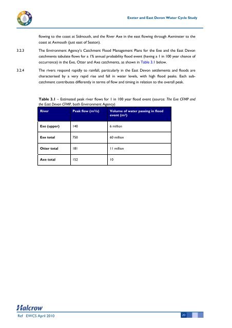
3.2.3 The Environment Agency’s Catchment Flood Management Plans for the Exe and the <strong>East</strong> <strong>Devon</strong><br />
catchments tabulate flows for a 1% annual probability flood event (having a 1 in 100 year chance of<br />
occurrence) in the Exe, Otter and Axe catchments, as shown in Table 3.1 below.<br />
3.2.4 The rivers respond rapidly to rainfall, particularly in the <strong>East</strong> <strong>Devon</strong> settlements and floods are<br />
characterised by a very rapid rise and fall in water levels, with high flood peaks. Each subcatchment<br />
contributes differently in terms of flow and timing in relation to the overall peak.<br />
Table 3.1 – Estimated peak river flows for 1 in 100 year flood event (source: The Exe CFMP and<br />
the <strong>East</strong> <strong>Devon</strong> CFMP, both Environment Agency)<br />
River Peak flow (m 3/s) Volume of water passing in flood<br />
event (m 3)<br />
Exe (upper) 140 6 million<br />
Exe total 750 60 million<br />
Otter total 181 11 million<br />
Axe total 152 10<br />
20