Water Cycle Study - East Devon District Council
Water Cycle Study - East Devon District Council
Water Cycle Study - East Devon District Council

Create successful ePaper yourself
Turn your PDF publications into a flip-book with our unique Google optimized e-Paper software.
Exeter and <strong>East</strong> <strong>Devon</strong> <strong>Water</strong> <strong>Cycle</strong> <strong>Study</strong><br />
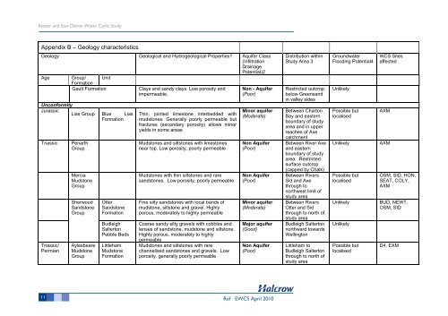
Appendix B – Geology characteristics<br />
Geology Geological and Hydrogeological Properties1 Aquifer Class<br />
(Infiltration<br />
Drainage<br />
Potential)2<br />
Age Group/ Unit<br />
Formation<br />
Gault Formation Clays and sandy clays. Low porosity and<br />
impermeable.<br />
Unconformity<br />
Jurassic<br />
Lias Group Blue Lias<br />
Formation<br />
Triassic Penarth<br />
Group<br />
Triassic/<br />
Permian<br />
Mercia<br />
Mudstone<br />
Group<br />
Sherwood<br />
Sandstone<br />
Group<br />
Aylesbeare<br />
Mudstone<br />
Group<br />
Otter<br />
Sandstone<br />
Formation<br />
Budleigh<br />
Salterton<br />
Pebble Beds<br />
Littleham<br />
Mudstone<br />
Formation<br />
Thin, jointed limestone interbedded with<br />
mudstones. Generally poorly permeable but<br />
fractures (secondary porosity) allows minor<br />
yields in some areas<br />
Mudstones and siltstones with limestones<br />
near top. Low porosity, poorly permeable<br />
Mudstones with thin siltstones and rare<br />
sandstones. Low porosity, poorly permeable<br />
Fine silty sandstones with local bands of<br />
mudstone, siltstone and gravel. Highly<br />
porous, moderately to highly permeable<br />
Coarse sandy silty gravels with cobbles and<br />
lenses of sandstone, mudstone and siltstone.<br />
Highly porous, moderately to highly<br />
permeable<br />
Mudstones and siltstones with rare<br />
channelised sandstones and gravels. Low<br />
porosity, generally poorly permeable<br />
Non - Aquifer<br />
(Poor)<br />
Minor aquifer<br />
(Moderate)<br />
Non Aquifer<br />
(Poor)<br />
Non Aquifer<br />
(Poor)<br />
Minor aquifer<br />
(Moderate)<br />
Major aquifer<br />
(Good)<br />
Non Aquifer<br />
(Poor)<br />
11 Ref EWCS April 2010<br />
Distribution within<br />
<strong>Study</strong> Area 3<br />
Restricted outcrop<br />
below Greensand<br />
in valley sides<br />
Between Charton<br />
Bay and eastern<br />
boundary of study<br />
area and in upper<br />
reaches of Axe<br />
catchment<br />
Between River Axe<br />
and eastern<br />
boundary of study<br />
area. Restricted<br />
surface outcrop<br />
(capped by Chalk)<br />
Between Rivers<br />
Sid and Axe<br />
through to<br />
northwest limit of<br />
study area<br />
Between Rivers<br />
Otter and Sid<br />
through to north of<br />
study area<br />
Budleigh Salterton<br />
northward towards<br />
Wellington<br />
Littleham to<br />
Budleigh Salterton<br />
through to north of<br />
study area<br />
Groundwater<br />
Flooding Potential4<br />
Unlikely<br />
Possible but<br />
localised<br />
WCS Sites<br />
affected<br />
AXM<br />
Unlikely AXM<br />
Possible but<br />
localised<br />
OSM, SID, HON,<br />
SEAT, COLY,<br />
AXM<br />
Unlikely BUD, NEWT,<br />
OSM, SID<br />
Unlikely<br />
Possible but<br />
localised<br />
D4, EXM