Novapoint Civil Construction
Novapoint Civil Construction
Novapoint Civil Construction

Create successful ePaper yourself
Turn your PDF publications into a flip-book with our unique Google optimized e-Paper software.
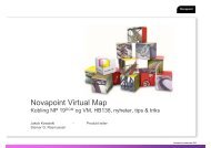
Sandvika east surface section: Early version of the model<br />
BACKGROUND<br />
The development of a 3D model was initially not a<br />
part of the agreement with The Norwegian<br />
National Rail Administration. In a separate meeting<br />
with The Norwegian National Rail<br />
Administration it was discussed whether to use<br />
this type of technology and working methodology<br />
in the work. We and The Norwegian National Rail<br />
Administration both saw the potential and the<br />
many opportunities it could offer and it was therefore<br />
agreed to initially establish models for both<br />
the surface sections (Lysaker west and Sandvika east).<br />
The start point of this work was the setting up of<br />
models of the substructure. This work should also<br />
be started immediately so that the basic model<br />
was ready by the time the first track plan version<br />
was completed.<br />
TEChNOLOGY AND CONTENTS<br />
The work started immediately. It was decided that<br />
<strong>Novapoint</strong> Virtual Map should be used as a tool.<br />
This is a quick and efficient tool for updating the<br />
model as planning work progresses and is simple<br />
for all parties to use. Procedures for working with<br />
the model for the different professional areas were<br />
set up, so that we could include all constructions<br />
directly into the model and generate an updated<br />
model in a short space of time.<br />
The existing situation for both surface sections<br />
was set up using existing maps and associated<br />
orthophotos. It was also agreed to incorporate<br />
planned elements continuously, such as:<br />
• Track geometry<br />
• All constructions (portals, tunnels, walls etc)<br />
• Fences/railings<br />
• Vegetation planting plans<br />
• Road geometry and emergency service areas<br />
• Railway engineering installations such as KL<br />
masts and cable ducts<br />
• Rig areas<br />
The model was initially used at internal working<br />
meetings with The Norwegian National Rail<br />
22<br />
Sandvika east surface section: Demo construction model<br />
Administration as a basis for discussions and to<br />
quality control solutions. It was in addition used to<br />
extract still pictures from agreed view points to<br />
present the different solutions.<br />
The model was used more and more actively and<br />
updated continuously as the planning work progressed.<br />
We, working with The Norwegian National<br />
Rail Administration, saw several opportunities to<br />
expand the model geographically, its content and<br />
not least into more areas of application.<br />
The work was expanded, at the request of the<br />
Norwegian National Rail Administration, to include:<br />
• The option to drive through the entire section.<br />
Entire tunnel sections should therefore be<br />
modelled including all details such as niches,<br />
fans, suspended masts, emergency tele<br />
phones, block telephones and other installations<br />
in the tunnel.<br />
• Establish routes for different types of train<br />
• <strong>Construction</strong> models for all rig areas including<br />
transverse tunnels with loading stations<br />
• New Lysaker station. Basis was received from<br />
Cowi, who had set up a model of the station<br />
previously<br />
• All main signals, repeat signals and dwarf<br />
signals for the stations<br />
• All markers<br />
• DVD film for use in information meetings with<br />
affected neighbours<br />
I.e. Everything which is planned and visible along<br />
the entire section in 3D.<br />
AREAS OF USAGE AND ExPERIENCE<br />
How was the model used in the project group and<br />
by the client?<br />
As mentioned previously, the model was used in<br />
all types of meetings and was on average shown<br />
once a week in different forums (planning meetings,<br />
land owner meetings, information meetings,<br />
presentations, professional groups etc). This tool<br />
was also perfect for: