Novapoint Civil Construction
Novapoint Civil Construction
Novapoint Civil Construction

Create successful ePaper yourself
Turn your PDF publications into a flip-book with our unique Google optimized e-Paper software.
arrived at. This is therefore a cross-profession iteration<br />
process up to the delivery of working drawings<br />
and surveying data. Surveying data should not<br />
be delivered to the construction site before this is<br />
checked in the VR model. The working method is<br />
fully dependant on these procedures being followed<br />
and that no one takes ‘short cuts’ and delivers data<br />
to the construction site without it being checked in<br />
the 3D model. The VR model only contains planned<br />
data. Data shown in the VR model therefore always<br />
corresponds with surveying data and working drawings.<br />
The solutions are evaluated and checked in the<br />
VRmodel, including the following:<br />
• Aesthetics<br />
• Technical solutions<br />
• Alignment<br />
• Visibility control<br />
• Geometric deviations<br />
• Conflicts between the different site components<br />
(foundations, lines, manholes, etc.)<br />
<strong>Novapoint</strong> Virtual Map is developed such that the<br />
model can be organised in groups and with the<br />
option to turn these off and on. A road surface can<br />
therefore be switched off to view the infrastructure<br />
under the ground.<br />
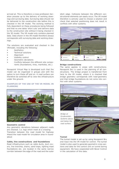
ExAMPLES OF ThE USE OF ThE VR MODEL IN<br />
PLANNING<br />
Evaluation of alignment and visibility<br />
Picture from the VR model of Braut roundabout.<br />
Geometric control<br />
Any geometric deviations between adjacent roads<br />
are checked. I.e. legs which meet at a crossing.<br />
Transition between the road model for highway<br />
44and the road model for circulation area in roundabout<br />
Cable, line constructions and foundations<br />
Road infrastructure such as cable ducts, duct covers,<br />
line trenches, drains, sand traps, lighting mast<br />
foundations etc. are located in the same narrow<br />
corridor between the edge of the road and the outer<br />
ditch edge. Collisions between the different constructional<br />
elements can easily occur. The VR model<br />
therefore is actively used to choose a solution and<br />
check that selected positioning does not result in<br />
conflicts with other systems.<br />
Bilde fra VR-modellen<br />
under vegbanen<br />
Bridge constructions<br />
The same applies in areas with constructions.<br />
<strong>Novapoint</strong> Bru is used in the planning of all constructions.<br />
The bridge project is transferred from<br />
here to the VR model, where it is checked that<br />
bridge geometry corresponds with road-geometry<br />
and that bridge foundations do not come into conflict<br />
with other systems.<br />
Bridge at<br />
Grudevarden.<br />
Systems above<br />
and below the<br />
road surface.<br />
Tunnel<br />
The tunnel model is set up by using <strong>Novapoint</strong> Bru<br />
and input into the VR model for control. The tunnel<br />
model is also used to generate geometric cross sections<br />
and data for the control unit on tunnel boring<br />
equipment. We have cooperated with Bever Control<br />
in the calculation of this data.<br />
9