plan estratégico para el drenaje pluvial del sur de ... - sinat - Semarnat
plan estratégico para el drenaje pluvial del sur de ... - sinat - Semarnat
plan estratégico para el drenaje pluvial del sur de ... - sinat - Semarnat

Create successful ePaper yourself
Turn your PDF publications into a flip-book with our unique Google optimized e-Paper software.
Huracanes<br />
MANIFESTACIÓN DE IMPACTO AMBIENTAL MODALIDAD PARTICULAR SECTOR HIDRÁULICO<br />
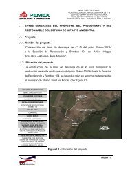
PROYECTO. PLAN ESTRATÉGICO PARA EL DRENAJE PLUVIAL DEL SUR DE TAMAULIPAS:<br />
OBRAS DE DRENAJE PLUVIAL EN LA DIVISORIA TAMPICO-ALTAMIRA, EN ALTAMIRA, TAM.<br />
OBRAS PARA EL DRENAJE PLUVIAL EN LA CALLE ALDAMA EN CD MADERO Y TAMPICO, TAM.<br />
AMPLIACIÓN DEL DREN DE LA COL. MORELOS Y CONSTRUCCIÓN DE DRENES EN LA ZONA CENTRO, CALLE<br />
ESPERANZA, BENITO JUÁREZ, COLÓN, Y PERIMETRAL FIDEL VELÁZQUEZ, EN TAMPICO, TAM.<br />
INSTITUTO METROPOLITANO DE PLANEACIÓN DEL SUR DE TAMAULIPAS<br />
Fenómenos climatológicos (nortes, tormentas tropicales y huracanes entre<br />
otros eventos climáticos extremos)<br />
La susceptibilidad en <strong>el</strong> sistema ambiental <strong>de</strong> recibir impactos <strong>de</strong> huracanes es alta,<br />
<strong>de</strong>bido a su localización geográfica sobre la línea costera y al ser tanto <strong>el</strong> océano<br />
Atlántico como <strong>el</strong> Golfo <strong>de</strong> México zonas propicias <strong>para</strong> la formación <strong>de</strong> estos<br />
meteoros. La temporada en que se presentan en <strong>el</strong> año es larga, tomando en cuenta<br />
que no todos los que logran formarse impactan sobre tierra causando daños graves.<br />
El inicio <strong>de</strong> la temporada <strong>de</strong> huracanes comienza en <strong>el</strong> mes <strong>de</strong> junio finalizando<br />
hasta noviembre.<br />
Registros <strong>de</strong> huracanes d<strong>el</strong> siglo XX que han tocado tierra en Tamaulipas y en zonas<br />
cercanas precisan <strong>de</strong>s<strong>de</strong> septiembre <strong>de</strong> 1933 cuando 3 meteoros causaron la<br />
pérdida <strong>de</strong> personas y daños materiales en Tampico, en <strong>el</strong> mismo mes pero <strong>de</strong> 1944,<br />
dos <strong>de</strong> estos fenómenos climatológicos provocaron fuertes avenidas en <strong>el</strong> río<br />
Pánuco. El año <strong>de</strong> 1955 fue <strong>el</strong> más <strong>de</strong>vastador que se haya registrado <strong>para</strong> <strong>el</strong><br />
municipio <strong>de</strong> Tampico, ya que en <strong>el</strong> mes <strong>de</strong> septiembre los huracanes Gladys, Hilda<br />
y Janet se presentaron con una intensidad en vientos y lluvias alcanzando en la<br />
escala <strong>de</strong> Saffir-Simpson como huracanes <strong>de</strong> categoría V. Los huracanes Inés en<br />
octubre <strong>de</strong> 1966 y Beulah en septiembre <strong>de</strong> 1967 <strong>de</strong> categoría V originaron fuertes<br />
lluvias en la zona. En los años <strong>de</strong> 1970, 1975 y 1977, se presentaron los huracanes<br />
Elda, Caroline y Anita respectivamente, siendo éste último <strong>el</strong> causante <strong>de</strong> <strong>de</strong>cesos<br />
humanos y daños materiales en <strong>el</strong> estado <strong>de</strong> Tamaulipas e inundaciones en<br />
Tampico.<br />
En la siguiente figura se representa la trayectoria <strong>de</strong> los huracanes que formaron<br />
CAPÍTULO IV | Pág. 6