plan estratégico para el drenaje pluvial del sur de ... - sinat - Semarnat
plan estratégico para el drenaje pluvial del sur de ... - sinat - Semarnat
plan estratégico para el drenaje pluvial del sur de ... - sinat - Semarnat

You also want an ePaper? Increase the reach of your titles
YUMPU automatically turns print PDFs into web optimized ePapers that Google loves.
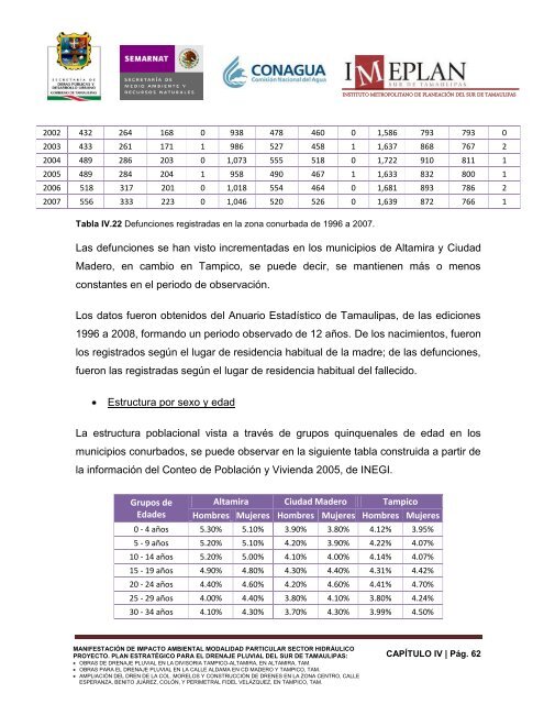
INSTITUTO METROPOLITANO DE PLANEACIÓN DEL SUR DE TAMAULIPAS<br />
2002 432 264 168 0 938 478 460 0 1,586 793 793 0<br />
2003 433 261 171 1 986 527 458 1 1,637 868 767 2<br />
2004 489 286 203 0 1,073 555 518 0 1,722 910 811 1<br />
2005 489 284 204 1 958 490 467 1 1,633 832 800 1<br />
2006 518 317 201 0 1,018 554 464 0 1,681 893 786 2<br />
2007 556 333 223 0 1,046 520 526 0 1,639 872 766 1<br />
Tabla IV.22 Defunciones registradas en la zona conurbada <strong>de</strong> 1996 a 2007.<br />
Las <strong>de</strong>funciones se han visto incrementadas en los municipios <strong>de</strong> Altamira y Ciudad<br />
Ma<strong>de</strong>ro, en cambio en Tampico, se pue<strong>de</strong> <strong>de</strong>cir, se mantienen más o menos<br />
constantes en <strong>el</strong> periodo <strong>de</strong> observación.<br />
Los datos fueron obtenidos d<strong>el</strong> Anuario Estadístico <strong>de</strong> Tamaulipas, <strong>de</strong> las ediciones<br />
1996 a 2008, formando un periodo observado <strong>de</strong> 12 años. De los nacimientos, fueron<br />
los registrados según <strong>el</strong> lugar <strong>de</strong> resi<strong>de</strong>ncia habitual <strong>de</strong> la madre; <strong>de</strong> las <strong>de</strong>funciones,<br />
fueron las registradas según <strong>el</strong> lugar <strong>de</strong> resi<strong>de</strong>ncia habitual d<strong>el</strong> fallecido.<br />
Estructura por sexo y edad<br />
La estructura poblacional vista a través <strong>de</strong> grupos quinquenales <strong>de</strong> edad en los<br />
municipios conurbados, se pue<strong>de</strong> observar en la siguiente tabla construida a partir <strong>de</strong><br />
la información d<strong>el</strong> Conteo <strong>de</strong> Población y Vivienda 2005, <strong>de</strong> INEGI.<br />
Grupos <strong>de</strong><br />
Eda<strong>de</strong>s<br />
Altamira Ciudad Ma<strong>de</strong>ro Tampico<br />
Hombres Mujeres Hombres Mujeres Hombres Mujeres<br />
0 - 4 años 5.30% 5.10% 3.90% 3.80% 4.12% 3.95%<br />
5 - 9 años 5.20% 5.10% 4.20% 3.90% 4.22% 4.07%<br />
10 - 14 años 5.20% 5.00% 4.10% 4.00% 4.14% 4.07%<br />
15 - 19 años 4.90% 4.80% 4.30% 4.40% 4.31% 4.42%<br />
20 - 24 años 4.40% 4.60% 4.20% 4.60% 4.41% 4.70%<br />
25 - 29 años 4.00% 4.40% 3.80% 4.10% 3.80% 4.24%<br />
30 - 34 años 4.10% 4.30% 3.70% 4.30% 3.99% 4.50%<br />
MANIFESTACIÓN DE IMPACTO AMBIENTAL MODALIDAD PARTICULAR SECTOR HIDRÁULICO<br />
PROYECTO. PLAN ESTRATÉGICO PARA EL DRENAJE PLUVIAL DEL SUR DE TAMAULIPAS:<br />
OBRAS DE DRENAJE PLUVIAL EN LA DIVISORIA TAMPICO-ALTAMIRA, EN ALTAMIRA, TAM.<br />
OBRAS PARA EL DRENAJE PLUVIAL EN LA CALLE ALDAMA EN CD MADERO Y TAMPICO, TAM.<br />
AMPLIACIÓN DEL DREN DE LA COL. MORELOS Y CONSTRUCCIÓN DE DRENES EN LA ZONA CENTRO, CALLE<br />
ESPERANZA, BENITO JUÁREZ, COLÓN, Y PERIMETRAL FIDEL VELÁZQUEZ, EN TAMPICO, TAM.<br />
CAPÍTULO IV | Pág. 62