plan estratégico para el drenaje pluvial del sur de ... - sinat - Semarnat
plan estratégico para el drenaje pluvial del sur de ... - sinat - Semarnat
plan estratégico para el drenaje pluvial del sur de ... - sinat - Semarnat

Create successful ePaper yourself
Turn your PDF publications into a flip-book with our unique Google optimized e-Paper software.
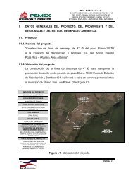
MANIFESTACIÓN DE IMPACTO AMBIENTAL MODALIDAD PARTICULAR SECTOR HIDRÁULICO<br />
PROYECTO. PLAN ESTRATÉGICO PARA EL DRENAJE PLUVIAL DEL SUR DE TAMAULIPAS:<br />
OBRAS DE DRENAJE PLUVIAL EN LA DIVISORIA TAMPICO-ALTAMIRA, EN ALTAMIRA, TAM.<br />
OBRAS PARA EL DRENAJE PLUVIAL EN LA CALLE ALDAMA EN CD MADERO Y TAMPICO, TAM.<br />
AMPLIACIÓN DEL DREN DE LA COL. MORELOS Y CONSTRUCCIÓN DE DRENES EN LA ZONA CENTRO, CALLE<br />
ESPERANZA, BENITO JUÁREZ, COLÓN, Y PERIMETRAL FIDEL VELÁZQUEZ, EN TAMPICO, TAM.<br />
INSTITUTO METROPOLITANO DE PLANEACIÓN DEL SUR DE TAMAULIPAS<br />
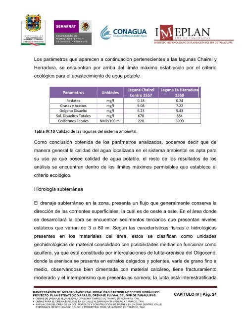
Los parámetros que aparecen a continuación pertenecientes a las lagunas Chair<strong>el</strong> y<br />
Herradura, se encuentran por arriba d<strong>el</strong> límite máximo establecido por <strong>el</strong> criterio<br />
ecológico <strong>para</strong> <strong>el</strong> abastecimiento <strong>de</strong> agua potable.<br />
Parámetros Unida<strong>de</strong>s<br />
Laguna Chair<strong>el</strong><br />
Centro 2557<br />
Laguna La Herradura<br />
2559<br />
Fosfatos mg/l 0.18 0.24<br />
Grasas y Aceites mg/l 9.08 7.22<br />
Oxígeno Disu<strong>el</strong>to mg/l 6.23 5.43<br />
Sol. Disu<strong>el</strong>tos Totales mg/l 678 884<br />
Coliformes Fecales NMP/100 ml 220 3900<br />
Tabla IV.10 Calidad <strong>de</strong> las lagunas d<strong>el</strong> sistema ambiental.<br />
Como conclusión obtenida <strong>de</strong> los parámetros analizados, po<strong>de</strong>mos <strong>de</strong>cir que <strong>de</strong><br />
manera general la calidad d<strong>el</strong> agua localizada en <strong>el</strong> sistema ambiental es apta <strong>para</strong><br />
su uso ya que posee calidad <strong>de</strong> agua potable, <strong>el</strong> resto <strong>de</strong> los resultados <strong>de</strong> los<br />
análisis se encuentran <strong>de</strong>ntro <strong>de</strong> los límites máximos permisibles que establece <strong>el</strong><br />
criterio ecológico.<br />
Hidrología subterránea<br />
El <strong>drenaje</strong> subterráneo en la zona, presenta un flujo que generalmente conserva la<br />
dirección <strong>de</strong> las corrientes superficiales, la cuál es <strong>de</strong> oeste a este. En <strong>el</strong> área don<strong>de</strong><br />
se <strong>de</strong>sarrollará la obra se encuentran sedimentos terciarios que presentan niv<strong>el</strong>es<br />
estáticos que varían <strong>de</strong> 3 a 80 m. Según las características físicas e hidrológicas<br />
presentes en los materiales d<strong>el</strong> área, estos se clasifican como unida<strong>de</strong>s<br />
geohidrológicas <strong>de</strong> material consolidado con posibilida<strong>de</strong>s medias <strong>de</strong> funcionar como<br />
acuífero, ya que está constituida por intercalaciones <strong>de</strong> lutita-arenisca d<strong>el</strong> Oligoceno,<br />
don<strong>de</strong> la arenisca se presenta en estratos d<strong>el</strong>gados y potentes, varía <strong>de</strong> grano fino a<br />
medio, observándose bien cimentada con material calcáreo, tiene fracturamiento<br />
mo<strong>de</strong>rado y <strong>el</strong> intemperismo que presenta es somero; la lutita está interestratificada<br />
CAPÍTULO IV | Pág. 24