evaluación de los recursos hÃdricos manual para la ... - Infoiarna
evaluación de los recursos hÃdricos manual para la ... - Infoiarna
evaluación de los recursos hÃdricos manual para la ... - Infoiarna

You also want an ePaper? Increase the reach of your titles
YUMPU automatically turns print PDFs into web optimized ePapers that Google loves.
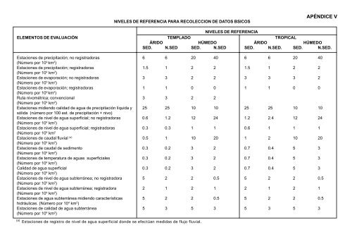
NIVELES DE REFERENCIA PARA RECOLECCION DE DATOS BSICOS<br />
NIVELES DE REFERENCIA<br />
ELEMENTOS DE EVALUACIÓN TEMPLADO TROPICAL<br />
ÁRIDO HÚMEDO ÁRIDO HÚMEDO<br />
SED. N.SED SED. N.SED SED. N.SED. SED. N.SED.<br />
Estaciones <strong>de</strong> precipitación; no registradoras 6 6 20 40 6 6 20 40<br />
(Número por 10 4 km 2 )<br />
Estaciones <strong>de</strong> precipitación; registradoras 1.5 1 2 2 1.5 1 2 2<br />
(Número por 10 4 km 2 )<br />
Estaciones <strong>de</strong> evaporación; no registradoras 3 3 2 2 3 3 3 2<br />
(Número por 10 5 km 2 )<br />
Estaciones <strong>de</strong> evaporación; registradoras 1 1 0 0 1 1 0 0<br />
(Número por 10 6 km 2 )<br />
Ruta nivométrica; convencional 3 3 2 2<br />
(Número por 10 4 km 2 )<br />
Estaciones midiendo calidad <strong>de</strong> agua <strong>de</strong> precipitación líquida y 25 25 10 10 25 25 10 10<br />
sólida (número por 100 est. <strong>de</strong> precipitación + nivo)<br />
Estaciones <strong>de</strong> nivel <strong>de</strong> agua superficial; no registradoras 0.6 1.2 12 24 1.2 2.4 12 24<br />
(Número por 10 4 km 2 )<br />
Estaciones <strong>de</strong> nivel <strong>de</strong> agua superficial; registradoras 0.3 0.3 1 1 0.6 1 1 1<br />
(Número por 10 4 km 2<br />
Estaciones <strong>de</strong> caudal fluvial (a) 0.5 1 10 20 1 2 10 20<br />
(Número por 10 4 km 2 )<br />
Estaciones <strong>de</strong> caudal <strong>de</strong> sedimento 0.3 0.2 3 2 0.7 0.4 5 3<br />
(Número por 10 4 km 2 )<br />
Estaciones <strong>de</strong> temperatura <strong>de</strong> aguas superficiales 0.3 0.2 3 2 0.7 0.4 5 3<br />
(Número por 10 4 km 2 )<br />
Calidad <strong>de</strong> agua superficial 0.3 0.2 3 2 0.7 0.4 5 3<br />
(Número por 10 4 km 2 )<br />
Estaciones <strong>de</strong> nivel <strong>de</strong> agua subterránea; no registradora 5 2 2 0.5 5 2 2 0.5<br />
(Número por 10 4 km 2 )<br />
Estaciones <strong>de</strong> nivel <strong>de</strong> agua subterránea; registradora 2 1 2 1 2 1 2 1<br />
(Número por 10 4 km 2 )<br />
Estaciones <strong>de</strong> agua subterránea midiendo características 5 2 2 0.5 5 2 2 0.5<br />
hidráulicas. (Número por 10 4 km 2 )<br />
Estaciones <strong>de</strong> calidad <strong>de</strong> agua subterránea 5 3 5 3 5 3 5 3<br />
(Número por 10 4 km 2 )<br />
(a)<br />
Estaciones <strong>de</strong> registro <strong>de</strong> nivel <strong>de</strong> agua superficial don<strong>de</strong> se efectúan medidas <strong>de</strong> flujo fluvial.<br />
APÉNDICE V<br />
132 Evaluación <strong>de</strong> <strong>los</strong> Recursos Hídricos - OMM - UNESCO