Dall'immagine al modello Note sulla cartografia geometrica in Italia ...
Dall'immagine al modello Note sulla cartografia geometrica in Italia ...
Dall'immagine al modello Note sulla cartografia geometrica in Italia ...

You also want an ePaper? Increase the reach of your titles
YUMPU automatically turns print PDFs into web optimized ePapers that Google loves.
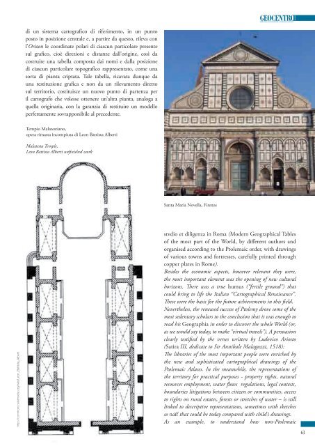
di un sistema cartografico di riferimento, <strong>in</strong> un puntoposto <strong>in</strong> posizione centr<strong>al</strong>e e, a partire da questo, rileva conl’Orizon le coord<strong>in</strong>ate polari di ciascun particolare presentesul grafico, cioè direzioni e distanze d<strong>al</strong>l’orig<strong>in</strong>e, così dacostruire una tabella composta dai nomi e d<strong>al</strong>la posizionedi ciascun particolare topografico rappresentato, come unasorta di pianta criptata. T<strong>al</strong>e tabella, ricavata dunque dauna restituzione grafica e non da un rilevamento direttosul territorio, costituisce un nuovo punto di partenza peril cartografo che volesse ottenere un’<strong>al</strong>tra pianta, an<strong>al</strong>oga aquella orig<strong>in</strong>aria, con la garanzia di restituire un <strong>modello</strong>perfettamente sovrapponibile <strong>al</strong> precedente.Tempio M<strong>al</strong>atestiano,opera rimasta <strong>in</strong>compiuta di Leon Battista AlbertiM<strong>al</strong>atesta Temple,Leon Battista Alberti unf<strong>in</strong>ished workSanta Maria Novella, Firenzehttp://commons.wikimedia.org/wiki/Leon_Battista_Albertistvdio et diligenza <strong>in</strong> Roma (Modern Geographic<strong>al</strong> Tablesof the most part of the World, by different authors andorganised accord<strong>in</strong>g to the Ptolemaic order, with draw<strong>in</strong>gsof various towns and fortresses, carefully pr<strong>in</strong>ted throughcopper plates <strong>in</strong> Rome).Besides the economic aspects, however relevant they were,the most important element was the open<strong>in</strong>g of new cultur<strong>al</strong>horizons. There was a true humus (“fertile ground”) thatcould br<strong>in</strong>g to life the It<strong>al</strong>ian “Cartographic<strong>al</strong> Renaissance”.These were the basis for the future achievements <strong>in</strong> this fi eld.Nevertheless, the renewed success of Ptolemy drove some of themost sedentary scholars to the conclusion that it was enough toread his Geographia <strong>in</strong> order to discover the whole World (or,as we would say today, to make “virtu<strong>al</strong> travels”). A persuasionclearly testifi ed by the verses written by Ludovico Ariosto(Satira III, dedicate to Sir Annib<strong>al</strong>e M<strong>al</strong>aguzzi, 1518):The libraries of the most important people were enriched bythe new and sophisticated cartographic<strong>al</strong> draw<strong>in</strong>gs of thePtolemaic Atlases. In the meanwhile, the representations ofthe territory for practic<strong>al</strong> purposes - property rights, natur<strong>al</strong>resources employment, water fl ows regulations, leg<strong>al</strong> contests,boundaries litigations between citizen or communities, accessto rights on rur<strong>al</strong> estates, forests or stretches of water – is stilll<strong>in</strong>ked to descriptive representations, sometimes with sketchesso naïf that could be today compared with child’s draw<strong>in</strong>gs.As an example, to understand how non-Ptolemaic63