). Il passaggio d<strong>al</strong> rilievo <strong>al</strong>la carta avviene poi attraverso unas<strong>in</strong>tesi <strong>in</strong>dividu<strong>al</strong>e di elementi percettivi, metrici ed ord<strong>in</strong><strong>al</strong>i,che propongono sempre una visione diagrammatica dellospazio, percepito e del<strong>in</strong>eato nella sua unitarietà.Il suo più <strong>al</strong>to contributo <strong>al</strong>la rappresentazione del territorioriguarda speci<strong>al</strong>mente la componente vertic<strong>al</strong>e dei monti edei laghi. Il metodo che Leonardo impiega nella restituzionegrafica delle masse orografiche si basa sul tentativo didel<strong>in</strong>eazione delle forme di monti e coll<strong>in</strong>e nel rispetto deiloro mutui rapporti di proporzion<strong>al</strong>ità e nell’<strong>in</strong>troduzionedella sua teoria delle ombre, che conferisce <strong>al</strong>le carte unaforza comunicativa senza precedenti e conferma l’importanzacartographic<strong>al</strong> science.T<strong>al</strong>k<strong>in</strong>g about the representation, dur<strong>in</strong>g the Renaissancenew surveyors, pa<strong>in</strong>ters and m<strong>in</strong>iaturists went further <strong>in</strong>tothe creation of maps with greater power of description andexpression.After more or less fi fty years s<strong>in</strong>ce the publish<strong>in</strong>g of Alberti’sessays, another genius <strong>in</strong> both Art and Science, Leonardo daV<strong>in</strong>ci (1452-1519), gave a unique, orig<strong>in</strong><strong>al</strong> contributionto this discipl<strong>in</strong>e, thanks to the methods proposed by LeonBattista Alberti and to the Ptolemaic Geographia, both <strong>in</strong>the draw<strong>in</strong>g techniques from the re<strong>al</strong>ity (through perspective<strong>in</strong>struments such as the “Velo”, conceived by Alberti <strong>in</strong> orderto establish a geometric<strong>al</strong> correspondence with a perspectiveview) and <strong>in</strong> the methods of survey<strong>in</strong>g and sketch<strong>in</strong>g maps.Leonardo’s maps stand out a mile from the naïve and childishsketches re<strong>al</strong>ised by the surveyors and the experts of the time,even if his <strong>in</strong>terest for the cartographic<strong>al</strong> representation doesn’thave a profession<strong>al</strong> purpose.Leonardo isn’t a cartographer, but he de<strong>al</strong>s with this sciencefor scientifi c and an<strong>al</strong>ytic purposes: landscape plann<strong>in</strong>g andwar strategies.In order to understand his cartographic<strong>al</strong> work, we need totake a step beh<strong>in</strong>d, shift<strong>in</strong>g our focus from the maps to therepresentations more <strong>in</strong> gener<strong>al</strong>; that’s to say to the language ofthe draw<strong>in</strong>gs and of the pa<strong>in</strong>t<strong>in</strong>gs. For Leonardo, this latterwasn’t a mere visu<strong>al</strong> repetition of what was <strong>al</strong>ready known;<strong>in</strong>stead, it was “the key to open the world of phenomena” (asGiulio Carlo Argan said).The <strong>in</strong>novative basis of his cartographic<strong>al</strong> production, therefore,can be found <strong>in</strong> the rules enunciated <strong>in</strong> the Libro di pittura.The way Leonardo chooses to survey and graphic<strong>al</strong>ly representa piece of land is summarised <strong>in</strong> the rule given <strong>in</strong> his own note<strong>in</strong> the Manuscript L, France Institute (f. 21 r): “On the topof the hills and on theirs sides, look at the shapes of the landportions, at their division, and at <strong>al</strong>l the th<strong>in</strong>gs <strong>in</strong> front ofyou, and draw them <strong>in</strong> their own shape”. The transformationfrom the sketch to the map is done through a person<strong>al</strong> synthesisof perceptive elements, metric and ord<strong>in</strong><strong>al</strong>, <strong>al</strong>ways giv<strong>in</strong>g adiagrammatic<strong>al</strong> view of the land (conceived and representedas a whole).Leonardo’s contribution to an accurate landscape representationis particularly relevant for what concerns the vertic<strong>al</strong> componentof mounta<strong>in</strong>s and hydrography. In the graphic<strong>al</strong> reproductionof mounta<strong>in</strong>ous blocks, he tries to sketch the shapes of everymassif and hill follow<strong>in</strong>g their mutu<strong>al</strong> proportions. Moreover,his “theory of the shadows” gives to the maps a communicativepower never achieved before, a proof of the importance of acareful study on them. “… shades <strong>in</strong> pa<strong>in</strong>t<strong>in</strong>g need much more<strong>in</strong>vestigation and speculation than their outl<strong>in</strong>e; and evidenceof this precept is that the outl<strong>in</strong>e can be made to sh<strong>in</strong>e us<strong>in</strong>gveils transparency, or fl at glass placed between the eye and theth<strong>in</strong>g to be drawn; but this rule does not apply to shades, dueto the lack of sensitivity of their shape, for, more often than69
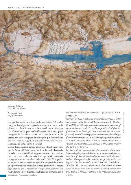
ANNO I | n. 6 | NOVEMBRE - DICEMBRE 2009Leonardo da V<strong>in</strong>ci,Carta della V<strong>al</strong>dichianaLeonardo da V<strong>in</strong>ci,Map of V<strong>al</strong>dichianache per Leonardo ha il loro profondo studio: “Di moltomaggiore <strong>in</strong>vestigazione e speculazione sono le ombre nellapittura che i loro l<strong>in</strong>eamenti; e la prova di questo s’<strong>in</strong>segnache i l<strong>in</strong>eamenti si possono lucidare con veli, o vetri piani<strong>in</strong>terposti fra l’occhio e la cosa che si deve lucidare; ma leombre non sono comprese da t<strong>al</strong>e regola, per l’<strong>in</strong>sensibilitàdei loro term<strong>in</strong>i, i qu<strong>al</strong>i il più delle volte sono confusi”(Leonardo da V<strong>in</strong>ci, Libro di Pittura).Così, è da riscontrare il geni<strong>al</strong>e uso di luce ed ombra, adottatoper la Carta dell’It<strong>al</strong>ia centro-nord, nella qu<strong>al</strong>e Leonardo<strong>in</strong>troduce una mod<strong>al</strong>ità di rappresentazione che consenteuna percezione delle variazioni di quota del territoriocartografato, senza precedenti nella storia della Cartografia,e che può essere riconosciuta come l’archetipo della tecnicadi rappresentazione orografica a t<strong>in</strong>te ipsometriche, ancoraoggi adottata per la re<strong>al</strong>izzazione degli atlanti scolastici delnostro tempo e riproducente con efficacia ed immediatezza ilconcetto di “più scuro più <strong>al</strong>to”.not, they are undefi ned or uncerta<strong>in</strong>...” (Leonardo da V<strong>in</strong>ci,c. 1508-10).Therefore, we have to take <strong>in</strong>to account the clever use of lightsand shadows <strong>in</strong> the Carta dell’It<strong>al</strong>ia centro-nord (W<strong>in</strong>dsor,RL 12277). In this map, Leonardo <strong>in</strong>troduces a new way ofrepresentation that makes it possible to perceive the diff erencesof <strong>al</strong>titude <strong>in</strong> the landscape. Such a method had never beenpreviously applied <strong>in</strong> cartography and constitutes the archetypeof the way to represent an <strong>al</strong>titude through hypsometric colours(a method nowadays still <strong>in</strong> use for school atlases and apractic<strong>al</strong> and understandable example of the abstract concept“the darker, the higher”).Together with the representation of a mounta<strong>in</strong> shape, evenLeonardo’s hydrographic<strong>al</strong> sketches are a demonstration of thesame idea of three-dimension<strong>al</strong>ity, obta<strong>in</strong>ed with the samemethod, <strong>al</strong>though with the opposite concept “the darker, thedeepest”. The best example is the Carta della V<strong>al</strong>dichiana(W<strong>in</strong>dsor, RL 12278r), where the sh<strong>al</strong>low stretch of water<strong>in</strong> the v<strong>al</strong>ley contrasts with the deepest waters of its tributaryfl ows, thanks to the use of diff erent tones of blue for every levelof depth.W<strong>in</strong>dsor Castle, Roy<strong>al</strong> Library, 12278r70