

GEOmedia 2 2016
La prima rivista italiana di geomatica
La prima rivista italiana di geomatica

You also want an ePaper? Increase the reach of your titles
YUMPU automatically turns print PDFs into web optimized ePapers that Google loves.
REPORT<br />
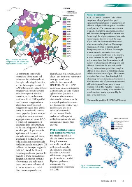
Fig. 2 - Esempio di CAP che<br />
comprendono più comuni nella<br />
regione Friuli Venezia Giulia.<br />
La continuità territoriale<br />
sopracitata viene meno nel<br />
momento in cui si scende nel<br />
dettaglio delle singole località<br />
servite dal recapito postale. I<br />
CAP infatti, sono stati attribuiti<br />
progressivamente alle diverse<br />
zone dove opera il servizio<br />
postale e, se da un lato sono<br />
stati identificati CAP specifici<br />
per i comuni maggiori (con<br />
addirittura suddivisioni di<br />
maggior dettaglio nelle grandi<br />
città), in alcuni casi i comuni<br />
meno popolosi (e non sempre<br />
contigui tra loro) sono stati<br />
aggregati sotto un unico CAP:<br />
il criterio di aggregazione è<br />
costituito dalle infrastrutture<br />
viarie che collegano le diverse<br />
località, per cui, per esempio,<br />
a più comuni ricadenti in<br />
una valle montana può essere<br />
attribuito il medesimo CAP,<br />
se le località sono servite dalla<br />
medesima strada principale. Ciò<br />
in linea con lo scopo originario<br />
del CAP, cioè di facilitare il<br />
recapito postale, ma poco utile<br />
quando si tratta di localizzare<br />
geograficamente un comune.<br />
Ne consegue che nelle zone<br />
meno densamente abitate, ci<br />
si ritrova spesso con codici<br />
di avviamento postale che<br />
identificano più comuni, che in<br />
alcuni casi non sono nemmeno<br />
contigui tra di loro.<br />
A livello internazionale<br />
[INSPIRE, 2014], il CAP<br />
costituisce un dato integrante<br />
delle stringhe di testo relative<br />
agli indirizzi (insieme a<br />
Comune, via e numero<br />
civico) ed è utilizzato anche<br />
a scopi di geolocalizzazione;<br />
nel documento citato, viene<br />
riconosciuto che non<br />
esiste un’uniformità<br />
di costruzione di tale<br />
codice né della qualità<br />
dell’informazione che vi è<br />
associata nei diversi Stati<br />
europei.<br />
Problematiche legate<br />
alle analisi territoriali<br />
Per meglio specificare<br />
ciò che è stato accennato<br />
fin qui, verranno<br />
ora analizzate alcune<br />
delle problematiche<br />
che rendono inadatto<br />
l’uso del CAP come<br />
riferimento geografico<br />
per le analisi territoriali.<br />
Il primo problema<br />
evidenziato è la<br />
discontinuità territoriale<br />
dei CAP.<br />
Postal Descriptor<br />
5.3.1.1.17. Postal Descriptor - The address<br />
component subtype “postal descriptor”<br />
represents the identification of a subdivision of<br />
addresses and postal delivery points created for<br />
postal purposes. The most common example<br />
of a postal descriptor is a post code associated<br />
with the name of the post office, town or area.<br />
Even though the original purpose of post codes<br />
was sorting and delivery of mail, the usage<br />
of post codes has been extended into many<br />
other sectors and applications. The concept,<br />
structure and formats of national postal<br />
descriptor systems are different. For example<br />
in some countries post codes are seen as a<br />
proper geographic subdivision of the country,<br />
in other countries the post code is regarded<br />
only as an attribute that characterizes a small<br />
number of adjacent postal delivery points and<br />
addresses. Sometimes the post code itself is<br />
the only information required for a complete<br />
address; in other situations both the post code<br />
and the associated name of post office or town<br />
is required. Sometimes there is a simple 1:1<br />
relationship between the code and the name; in<br />
other situations a set of postcodes are associated<br />
with a single post office or town. In some<br />
countries such as The Republic of Ireland, no<br />
post code system currently exists; therefore the<br />
postal descriptor is only represented by the<br />
name of the post town.<br />
(Estratto dalle specifiche INSPIRE sull’Address)<br />
Fig. 3 - Distribuzione della<br />
continuità territoriale dei CAP.<br />
<strong>GEOmedia</strong> n°2-<strong>2016</strong> 45


