


Create successful ePaper yourself
Turn your PDF publications into a flip-book with our unique Google optimized e-Paper software.
FOCUS<br />
Le date di acquisizione delle<br />
immagini sono il 12 luglio e 28<br />
luglio 2015.<br />
Operational Land Imager<br />
(OLI) e Thermal Infrared Sensor<br />
(TIRS) sono sensori presenti<br />
a bordo del satellite Landsat<br />
8, che è stato lanciato nel Febbraio<br />
2013. Landsat8 acquisisce<br />
immagini con una risoluzione<br />
temporale di 16 giorni su orbita<br />
ripetitiva, quasi polare, eliosincrona<br />
e circolare a 705 km di<br />
altitudine.<br />
Il sensore Operational Land<br />
Imager (OLI) include 9 bande<br />
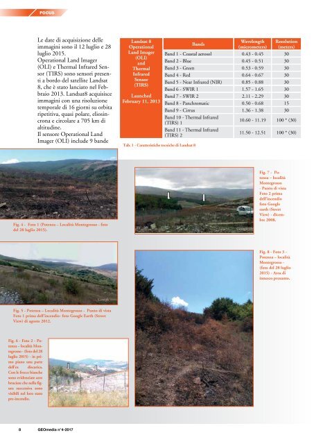
Landsat 8<br />
Operational<br />
Land Imager<br />
(OLI)<br />
and<br />
Thermal<br />
Infrared<br />
Sensor<br />
(TIRS)<br />
Launched<br />
February 11, 2013<br />
Tab. 1 - Caratteristiche tecniche di Landsat 8<br />
Bands<br />
Wavelength<br />
(micrometers)<br />
Resolution<br />
(meters)<br />
Band 1 - Coastal aerosol 0.43 - 0.45 30<br />
Band 2 - Blue 0.45 - 0.51 30<br />
Band 3 - Green 0.53 - 0.59 30<br />
Band 4 - Red 0.64 - 0.67 30<br />
Band 5 - Near Infrared (NIR) 0.85 - 0.88 30<br />
Band 6 - SWIR 1 1.57 - 1.65 30<br />
Band 7 - SWIR 2 2.11 - 2.29 30<br />
Band 8 - Panchromatic 0.50 - 0.68 15<br />
Band 9 - Cirrus 1.36 - 1.38 30<br />
Band 10 - Thermal Infrared<br />
(TIRS) 1<br />
10.60 - 11.19 100 * (30)<br />
Band 11 - Thermal Infrared<br />
(TIRS) 2<br />
11.50 - 12.51 100 * (30)<br />
Fig. 4 - Foto 1 (Potenza – Località Montegrosso - foto<br />
del 28 luglio 2015).<br />
Fig. 7 - Potenza<br />
– località<br />
Montegrosso<br />
- Punto di vista<br />
Foto 2 prima<br />
dell’incendio<br />
foto Google<br />
earth (Street<br />
View) - dicembre<br />
2008.<br />
Fig. 8 - Foto 3 -<br />
Potenza – località<br />
Montegrosso -<br />
(foto del 28 luglio<br />
2015) - Area di<br />
innesco presunto.<br />
Fig. 5 - Potenza – Località Montegrosso - Punto di vista<br />
Foto 1 prima dell’incendio- foto Google Earth (Street<br />
View) di agosto 2012.<br />
Fig. 6 - Foto 2 - Potenza<br />
– località Montegrosso<br />
- (foto del 28<br />
luglio 2015) - in primo<br />
piano una parte<br />
dell'ex discarica.<br />
Con le frecce bianche<br />
sono evidenziate aree<br />
bruciate che nella figura<br />
successiva sono<br />
visibili nel loro stato<br />
pre-incendio.<br />
8 <strong>GEOmedia</strong> n°4-<strong>2017</strong>


